

By Chris Pateras, Vice President for Strategy, Growth, and Operations, MAG

I first set foot in Latin America as a Special Forces advisor. Ecuador, then Colombia. Those early tours shaped how I think about operational complexity, partner capacity, and what it actually takes to achieve mission success when conditions are working against you. These include massively dense jungle canopy, adverse weather conditions, remote terrain, and adversaries who adapt faster than most bureaucracies can respond.
That was over 25 years ago. The region has changed. The threats have evolved. But the core challenge has not: getting the right information to the right decision-maker at the right time, across networks and organizations that were never designed to work together.
That challenge is a strategic imperative. Not a technical checkbox. Not a procurement requirement but a fundamental condition for mission success. And it is the lens through which I view MAG’s 12-year track record supporting USSOUTHCOM’s counter-narco-terrorism efforts across South America.
The operational landscape of counter-narcotics and counter-narco-terrorism within the U.S. Southern Command’s Area of Responsibility (AOR) demands unparalleled situational awareness, robust interagency coordination, and advanced technological integration. Decades of specialized missions across the landmasses and littorals of South and Central America have demonstrated that true mission success relies not merely on the deployment of advanced aviation platforms, but on the seamless, real-time integration of data across disparate networks.
As the defense and intelligence industries transition towards Modernizing the Arsenal of Freedom and open-architecture engineering frameworks, the fundamental metrics of operational success have shifted from raw flight hours to the precise speed of decision-making at the tactical edge.
The following statistical summary frames the current operational reality, demonstrating the vast strategic impact of optimized Airborne Intelligence, Surveillance, and Reconnaissance (ISR) in the region:
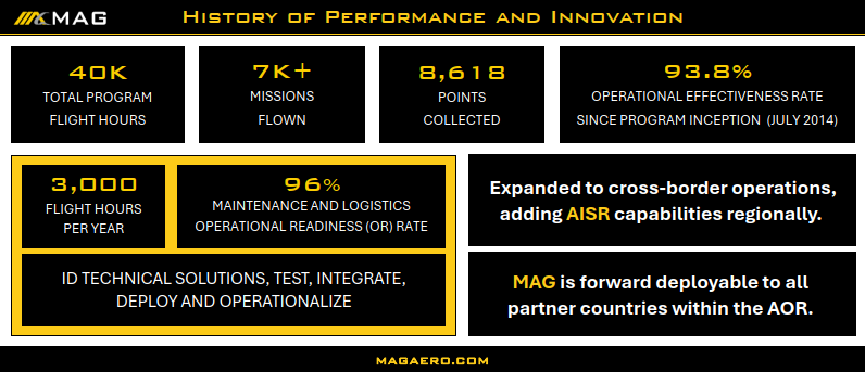
- Operational Readiness Sustainment: MAG’s contractor-owned, contractor-operated (COCO) airborne data collection programs executed in South America consistently sustain greater than 95% operational readiness across complex, highly austere environments, completely bypassing traditional infrastructure safety nets.
- Sensor-to-Shooter Kill-Chain Compression: The implementation of artificial intelligence-enabled decision aids and advanced multi-INT sensor fusion has dramatically compressed the sensor-to-shooter interval in counter-narcotics interdiction operations by nearly 30%, shrinking the engagement timeline from a legacy standard of 11.0 minutes down to just 7.7 minutes.
- Maritime Interdiction Volume: Approximately 80% of all interdictions involving U.S.-bound illegal drugs occur in the maritime domain, underscoring the absolute necessity for vast, persistent maritime domain awareness generated by airborne assets.
- Record-Breaking Disruptions: As of late August 2025, the Joint Interagency Task Force South supported the disruption of a historic 402.7 metric tons of cocaine, entirely surpassing the previous organizational record of 328.4 metric tons established earlier in the same year.
- Kinetic Strike Impact Metrics: Under the recently initiated Operation Southern Spear, U.S. military forces conducted 21 kinetic strikes against designated terrorist organizations (DTOs) between late 2025 and early 2026, resulting in the neutralization of 82 suspected narco-terrorists in defense of the homeland.
- Financial Denial and Seizure Totals: Single patrol deployments, such as that of the U.S. Coast Guard Cutter Stone in late 2025, have independently seized over 49,010 pounds of illicit narcotics, effectively denying transnational criminal organizations more than $362 million in illicit revenue in a single, coordinated maritime operation.
- Declining Border Apprehensions: Augmented by cutting-edge technology, including counter-unmanned aerial systems and airborne ISR, border apprehensions saw a 93% decline below the historic average by early 2026, correlating with a 20% decline in U.S. drug overdoses.
The Geopolitical Context: Navigating the Southern Hemisphere’s Complex Threat Landscape
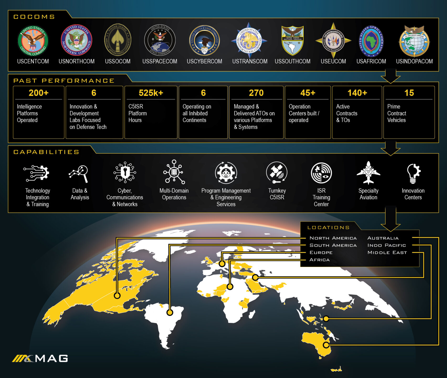
The geographical and geopolitical complexities of Latin America present a highly demanding environment for military, intelligence, and law enforcement operations. Defending the homeland at range, speed, and scale requires an intimate understanding of the adversaries operating within this theater.
The Rise of Designated Terrorist Organizations (DTOs) and Foreign Terrorist Organizations (FTOs)
The threat matrix in the Western Hemisphere is not static; it is enduring and rapidly evolving. According to recent congressional posture statements, thirteen Foreign Terrorist Organizations (FTOs) currently conduct campaigns of terror, violence, and corruption within the USSOUTHCOM AOR. These organizations are not merely legacy drug cartels; they are vast,
highly agile, illicit enterprises that generate hundreds of billions of dollars in revenue by trafficking in drugs, humans, weapons, and contraband. Their operations destabilize the entire region by terrorizing civilian populations, undermining host-nation governance, and posing a direct, existential threat to the security and sovereignty of the United States and every allied nation in the hemisphere.
The transition of these groups from simple trafficking networks to heavily armed, technologically capable adversaries force the Department of Defense (DoD) to adapt its operational posture.
The adversaries adapt their logistical routes, maritime conveyances, and organizational structures faster than conventional bureaucratic processes can counter. For example, cartels now employ shadow oil fleets, semi-submersible vessels, and highly coordinated go-fast boats hidden within commercial maritime traffic, necessitating advanced airborne ISR for detection. In regions like Haiti, FTO-driven violence and instability continually threaten to overwhelm regional security apparatuses, demanding persistent overwatch and intelligence fusion. Furthermore, the Americas Counter Cartel Coalition (Shield of Americas) —a partnership of South American and Caribbean nations, recently joined by Chile—has been established specifically to root out these narco-terrorism threats through deterrence-focused operations.
In highly sensitive and volatile border regions, such as: Colombia-Venezuela, the Darien Gap (Colombia-Panama), Ecuador-Colombia, Mexico-Guatemala, and Bolivia-Peru; host nations face immense challenges. Despite not being a major drug producer historically, Ecuador is confronting sophisticated drug trafficking methods utilizing containerized cargo and maritime routes, exacerbated by weak institutions and porous borders. Recent operations, such as “Operation Total Extermination,” highlight the escalating need for intelligence sharing and bilateral kinetic actions against cartel targets, although such operations carry significant risks of triggering cross-border diplomatic crises, as evidenced by incidents involving unexploded munitions.
The Operational Environment: Topographical and Meteorological Constraints
The physical geography of the USSOUTHCOM AOR inherently degrades traditional intelligence collection methods. Airborne ISR platforms must contend with massively dense jungle canopies in the Amazon basin, the towering altitudes of the Andes, and the expansive, unforgiving maritime transit zones of the Eastern Pacific Ocean and the Caribbean Sea.
Adverse weather conditions are ubiquitous. Persistent cloud cover, rapid-onset tropical storms, and heavy precipitation degrade single-sensor performance, frequently rendering traditional Electro-Optical/Infrared (EO/IR) sensors entirely ineffective. Targets are often concealed beneath triple-canopy vegetation or submerged just beneath the ocean surface, moving rapidly across international boundaries. Therefore, the core challenge has remained constant for decades: acquiring the right information through impenetrable environments, fusing it into actionable intelligence, and delivering it to the right decision-maker at the right time across systems that were historically never designed to communicate.
This environmental and geopolitical complexity forms the lens through which defense contractors and military strategists view long-term support for counter-narco-terrorism efforts. The procurement of ISR capabilities is not a technical checkbox; it is a fundamental, strategic condition for mission success and national security.
Doctrinal Evolution: From Multinational Law Enforcement to Kinetic Disruption
The doctrinal approach to countering illicit narcotics in the Western Hemisphere has evolved drastically over the past decade. It has transitioned from broad, multinational law enforcement support campaigns aimed at civilian prosecution to highly targeted, kinetic military operations aimed at eradicating designated terrorist threats.
Campaign Martillo: The Foundation of Multinational Detection and Monitoring
Initiated over a decade ago, Campaign Martillo (Hammer) served as a U.S., European, and Western Hemisphere defense effort targeting illicit trafficking routes in the coastal waters along the Central American isthmus. The operation successfully unified an unprecedented coalition of 14 countries, including Belize, Canada, Colombia, Costa Rica, El Salvador, France, Guatemala, Honduras, the Netherlands, Nicaragua, Panama, Spain, the United Kingdom, and the United States, alongside contributing efforts from nations like Chile.
Under the Martillo framework, the Department of Defense (DoD) served as the lead federal agency specifically tasked with the detection and monitoring (D&M) of the aerial and maritime transit of illegal drugs moving toward the U.S. The military provided critical operational support through Navy ships and airborne assets, while the actual interdictions—boarding, searching, seizing vessels, and making arrests—were strictly led and conducted by embarked U.S. Coast Guard Law Enforcement Detachments (LEDETs) or partner nation drug law enforcement agencies.
This campaign proved highly successful in its objective, yielding historic offloads and establishing the foundation for massive maritime seizures by leveraging persistent, wide-area airborne and maritime surveillance. It allowed the task force to increase its awareness of illicit trafficking patterns, with partner nations eventually supporting up to 50 percent of all interdictions and disruptions operations.
Operation Southern Spear: The Shift to Lethal Interdiction and Narco-Terrorism Eradication
As adversaries adapted and the scale of cartel violence threatened regional stability, the strategic mandate of the U.S. government shifted. In response to explicit presidential directives to counter narco-terrorists, the Department of Defense directed massive additional military forces to the USSOUTHCOM AOR under the banner of Maritime Interdiction Operation.
Announced in late 2025 by Secretary of War Pete Hegseth, OSS represents a significantly more aggressive and decisive posture designed to detect, disrupt, and entirely dismantle major international drug cartels that have been officially classified as Designated Terrorist Organizations (DTOs). Unlike previous operations that culminated almost exclusively in law enforcement apprehensions, OSS authorizes the lethal targeting of DTO members, affiliates, and vessels in international waters, provided they meet the criteria of hostile forces.
Operations are carried out by Joint Task Force (JTF) Southern Spear, which is actively supported by significant Naval and Marine Corps combat assets, including the deployment of the USS Stockdale, the Gerald R. Ford Carrier Strike Group, and elite elements of U.S. Special Operations Command (USSOCOM). The impact of this shift was immediate and profound. Between September 2025 and March 2026, the U.S. military struck at least 45 small boats utilized by cartels. During this period, the Department of Defense confirmed 21 direct kinetic strikes against designated terror organizations, resulting in the neutralization of 82 suspected narco-terrorists.
High-profile military engagements, such as the September 2 “double tap” strike directly ordered by USSOCOM leadership under established rules of engagement, highlight the decisive shift toward eliminating threats that pose vital risks to U.S. national interests. These lethal kinetic strikes in the Eastern Pacific Ocean explicitly signal that the Department of Defense will aggressively defend the homeland against narco-terrorism at range.

Joint Interagency Task Force South (JIATF-South): The Anchor of Intelligence Fusion
Central to the success of both law enforcement interdictions and kinetic military strikes is the Joint Interagency Task Force South (JIATF-South), headquartered at Naval Air Station Key West, Florida. JIATF-South serves as the premier intelligence fusion hub for the entire hemisphere, coordinating all-domain capabilities to facilitate the detection, monitoring, and ultimate interdiction of illicit trafficking.
The task force’s primary operational capability lies in its ability to ingest massive quantities of raw data from disparate airborne ISR assets, surface radars, and partner nation intelligence feeds. It then translates this unstructured data into highly accurate, targetable intelligence. JIATF-South is recognized universally as the “gold standard” for interagency and international cooperation, seamlessly integrating civilian foreign partners, military mission partners, and various SOUTHCOM components, including the 12th Air Force, U.S. Army South, and Special Operations Command South.
Record-Breaking Maritime Disruptions and Financial Denial
The intelligence generated by JIATF-South directly enables the U.S. Coast Guard and allied naval forces to conduct precise, intelligence-driven interdictions. The scale of these disruptions is staggering. By late August 2025, JIATF-South had supported the disruption of an unprecedented 402.7 metric tons of cocaine, breaking its previous record of 328.4 metric tons set just a month prior.
To comprehend the scale of the financial denial inflicted upon Transnational Criminal Organizations, one must examine the specific offloads facilitated by the intelligence products generated from airborne and maritime sensors.
| Operational Milestone / Asset | Date / Timeframe | Key Achievement & Volume Seized | Estimated Monetary Value / Impact |
|---|---|---|---|
| JIATF-South (Aggregate FY25) | August 2025 | Disruption of 402.7 metric tons of cocaine. | Record-breaking annual disruption, severely degrading FTO supply chains. |
| USCGC Hamilton | August 2025 | Offloaded 76,140 lbs of illicit narcotics. | Largest single cocaine offload in U.S. Coast Guard history. |
| USCGC Stone | November 2025 | Offloaded 49,010 lbs of illicit narcotics across 15 separate interdictions. | Over $362 million denied to TCOs; largest amount seized by a single cutter in one patrol. |
| USCGC Thetis | June 2025 | Offloaded 28,500 lbs of cocaine across four interdictions. | Estimated $211.3 million denied. |
| USCGC Calhoun | June 2025 | Offloaded 19,055 lbs of cocaine and marijuana. | Estimated $140.9 million denied. |
| USCGC Valiant | June 2025 | Offloaded 17,450 lbs of cocaine and 2,585 lbs of marijuana. | Estimated $132 million denied. |
| USCGC Tahoma | July 2025 | Offloaded 9,970 lbs of cocaine from an Eastern Pacific interdiction. | Estimated $73.7 million denied. |
These historic operations are linked to broader initiatives like Panama Express (PANEX) and Operation Take Back America, which utilize a prosecutor-led, intelligence-driven, multi-agency approach to identify and dismantle high-level criminal organizations. By denying criminal networks half a billion dollars in a single operation, the joint force actively prevents the cartels from reinvesting in the production and trafficking of lethal synthetic opioids, such as illegal fentanyl, which directly threaten the U.S. homeland.
MAG’s Airborne ISR Technologies: Penetrating the Unseen
Deploying an aircraft is only the foundational step in modern warfare; generating true decision advantage requires the continuous collection and fusion of multiple data streams into a coherent, actionable intelligence product. Airborne ISR acts as the central nervous system of the counter-narcotics mission, providing the critical detection and monitoring capabilities required to track highly evasive targets.
Overcoming the Dense Canopy with Multi-Sensor Suites
Single-sensor performance is frequently degraded by the unique environmental conditions of South America. If an airborne asset relies solely on one type of collection methodology, its operational window is severely restricted by weather patterns and natural geography. To counter this, advanced Contractor-Owned, Contractor-Operated (COCO) programs utilize sophisticated multi-sensor suites that provide redundant and complementary coverage.
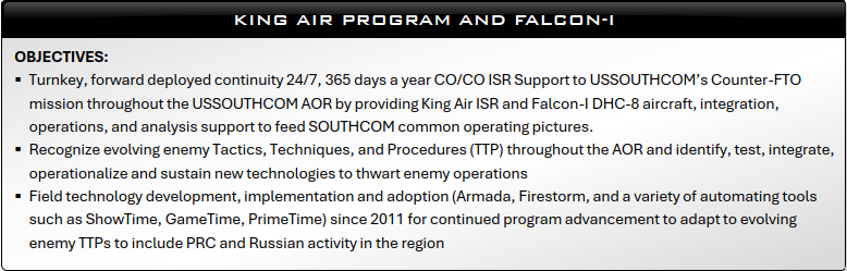
A prime operational example is the deployment of platforms like the FALCON I, which integrates a highly sophisticated triad of collection systems designed specifically to defeat the topographical constraints of the SOUTHCOM AOR :
- Electro-Optical/Infrared (EO/IR): Utilizing advanced gimbal systems like the Star SAFIRE 380HD, EO/IR sensors provide high-definition, full-motion video for direct visual identification and thermal tracking of personnel and vehicles. Infrared capabilities allow operators to detect the heat signatures of illicit drug laboratories hidden in the jungle or the engines of go-fast vessels operating at night. However, EO/IR is highly susceptible to visual occlusion; it cannot see through dense jungle canopies, heavy cloud cover, or heavy precipitation.
- Synthetic Aperture Radar (SAR): To defeat the limitations of EO/IR, airborne platforms integrate SAR. Unlike passive optical cameras, SAR actively emits microwave signals to construct high-resolution, two-dimensional images or three-dimensional reconstructions of landscapes. Crucially, the specific microwave frequencies utilized by SAR pass directly through cloud cover, rain, and fog. This capability allows the aircraft to cut through atmospheric conditions that render traditional EO/IR completely ineffective, ensuring persistent tracking of maritime targets even in severe tropical storms.
- Light Detection and Ranging (LiDAR): LiDAR utilizes millions of pulsed laser beams to measure variable distances to the Earth’s surface. In the context of counter-narcotics, LiDAR is an invaluable tool for structural mapping. By processing the laser returns that manage to pass through tiny gaps in the jungle canopy, advanced algorithms can strip away the vegetation to reveal the bare earth below. This capability allows analysts to detect hidden illicit infrastructure, such as clandestine airstrips, subterranean drug laboratories, or hidden transit routes that are entirely invisible from the air to the naked eye.
The Future of Airborne Collection: Quantum Sensors and Advanced Platforms
Looking beyond the current triad of EO/IR, SAR, and LiDAR, the defense industry is actively prototyping next-generation collection technologies. The invisible backbone of modern ISR is absolute precision timing and synchronization, which enables seamless sensor fusion and secure communications. However, legacy sensors and timing systems often constrain mission profiles due to excessive Size, Weight, and Power (SWaP) requirements. This inherent sensitivity-SWaP trade-off bottlenecks classical platforms.
To overcome this, the Department of Defense is exploring the integration of quantum sensors and clocks, which are not beholden to the same fundamental limitations as classical systems, offering unprecedented sensitivity for detecting magnetic anomalies or securing communications in contested environments. Additionally, the industry is continuously upgrading the platforms that carry these sensors. Recent contract competitions, such as the Army’s ATHENA-R program, have seen the conversion of business jets like the Bombardier Global 6500 into deep-sensing spy planes, phasing out legacy turboprop aircraft to provide greater range, altitude, and payload capacity for airborne intelligence missions.
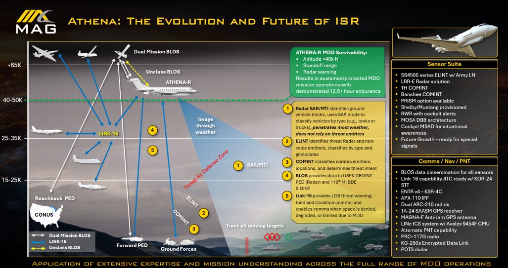
Fusing these diverse data streams—overlaying the structural anomalies detected by LiDAR with the all-weather tracking of SAR and the visual fidelity of EO/IR—fundamentally changes how analysts interpret the battlefield. However, this fusion is not a trivial task. It requires substantial analytical infrastructure, robust open-architecture edge computing, and a highly trained workforce to process the collected telemetry into a usable format for the end customer.
The Interoperability Crisis: The Strategic Cost of Siloed Data
Despite the overwhelming success of operations like Martillo and Southern Spear, a critical, systemic friction point persists at the operational edge: defense interoperability. As industry leaders frequently note, interoperability is not merely an optional feature to be requested during procurement; it is the fundamental mission itself.
The operational reality in Latin America frequently involves joint U.S. forces, host nation militaries, and contracted commercial assets attempting to coordinate complex interdiction missions while utilizing completely divergent technological systems. It is alarmingly common for a U.S. partner to run one highly advanced ISR platform while host nation ground forces rely on obsolete, legacy communication systems. Simultaneously, contracted assets may feed their sensor data through separate, proprietary pipelines. When these systems fail to communicate with one another in real-time, the result is a severely fragmented intelligence picture.
This fragmentation costs both missions and lives. Defense interoperability demands the seamless, automated integration of disparate military systems to exchange data and coordinate actions instantaneously. When the “sensor” (the airborne ISR platform detecting the target) and the “shooter” (the Coast Guard cutter or Special Forces team intercepting it) are separated by bureaucratic data silos or incompatible hardware standards, the adversary inherently gains the tactical advantage. Highly mobile target vessels and narco-trafficking convoys do not wait for allied communication architectures to synchronize; they exploit the latency. Therefore, closing the gap between detection and action is the paramount focus of modern defense strategy.
Navigating Disconnected, Intermittent, and Low-Bandwidth (DIL) Environments
The challenge of interoperability is compounded by the environment in which the data must travel. Airborne ISR platforms often operate in Disconnected, Intermittent, and Low-Bandwidth (DIL) environments, where establishing a constant, high-speed uplink to a centralized command center is impossible.
To ensure that critical intelligence still reaches the tactical edge, the Department of Defense is implementing stringent metadata policies under the authority of the DoD Chief Information Officer. These policies ensure that data is formatted according to VAULTIS principles (Visible, Accessible, Understandable, Linked, Trustworthy, Interoperable, and Secure).
Crucially, when data is exchanged in machine-to-machine messages from a sensor to a shooter, care must be taken to optimize the payload for transport efficiency. This is achieved through CETIS goals (Compact, Efficient, Trustworthy, Interoperable, and Secure). By ensuring that only the most critical, mission-essential metadata (such as the target Identification ID and the Date/Time stamp) travels in the payload, the military prevents network congestion and ensures that actionable intelligence successfully reaches the shooter, even in highly contested or low-bandwidth environments.
CJADC2 and the Compression of the Sensor-to-Shooter Kill Chain
To solve the interoperability crisis and permanently eradicate data silos, the Department of Defense is heavily investing in Combined Joint All-Domain Command and Control (CJADC2). CJADC2 is not a single software program or hardware box; it is an overarching operational strategy and digital framework designed to connect any sensor to any shooter across all warfighting domains (air, land, sea, space, and cyber), comprehensively enabled by artificial intelligence to achieve combined, decisive effects.
The core philosophy of CJADC2 is to “sense, make sense, and act” faster than the adversary can react. The primary metric of success for CJADC2 in the counter-narcotics mission is the rapid compression of the “sensor-to-shooter” interval. In dynamic environments, translating raw data into actionable intelligence requires the rapid triage of massive data streams. The traditional human-in-the-loop processing chain is often far too slow to exploit the ephemeral windows of targetable vulnerability presented by narco-trafficking networks.
Leveraging Artificial Intelligence for Decision Advantage
Extensive simulation data and recent operational fielding confirm that the integration of artificial intelligence into decision aids has successfully compressed the sensor-to-shooter interval by nearly 30 percent. Specifically, by automating data fusion, identifying anomalies instantly, and rapidly extracting critical metadata, AI algorithms have reduced overall kill-chain latency from a legacy baseline of 11.0 minutes down to just 7.7 minutes.
While a reduction of three and a half minutes may appear marginal in a peacetime administrative context, in a kinetic counter-narcotics interdiction operation targeting a fast-moving “go-fast” vessel, a semi-submersible, or a cartel convoy, that interval dictates the absolute difference between mission success and total failure.
AI enhances the military’s OODA loop (Observe, Orient, Decide, Act) by improving observation fidelity, enriching orientation through better sense-making context, and providing autonomous capabilities for decisive advantage. Units that invest in this level of interoperability, establish common data standards, and train across organizational boundaries operate at a fundamentally higher tempo than those clinging to legacy systems.
Enterprise Cloud Integration and the Microsoft Agreement
Achieving CJADC2 at a hemispheric scale requires an unprecedented IT backbone. To institutionalize sensor-to-shooter integration, the DoD relies on programs like the Joint Fires Network (JFN) and vast commercial enterprise agreements. Recently, the DoW awarded Microsoft Enterprise Agreement to Power Global Mission Readiness to arm the force with instantaneous, cross-domain intelligence sharing.
This agreement provides robust cloud subscriptions that accelerate the deployment of combat-critical AI and data analytics to guarantee decision superiority. Simultaneously, it secures targeted on-premises licensing to ensure unbroken operational continuity at the tactical edge, effectively fortifying classified enclaves against the constraints of DIL environments. By integrating these commercial software architectures, the DoD ensures that the raw radar returns captured by an airborne ISR asset in South America can be instantly processed in a cloud environment and pushed directly to the targeting computer of a Coast Guard cutter in the Eastern Pacific.
Architecting the Future: Sensor Open Systems Architecture (SOSA)
The legacy ISR architecture in Latin America, and globally, was historically built upon platform-centric paradigms. Each system operated as its own isolated technological island, hoarding collected data in proprietary, vendor-locked formats. Integration between distinct platforms from different defense contractors was a manual, agonizingly slow process, typically routed through human intermediaries. This outdated model is entirely incompatible with the operational tempo dictated by modern terrorist threats and the rapid pace of technological innovation.
The ongoing transition from siloed ISR to open-architecture frameworks is no longer a future aspiration; it is an active, mandatory requirement across the entire Department of Defense. Programs such as the Air Force Distributed Common Ground System (DCGS) have aggressively shifted away from proprietary, stove-piped original equipment manufacturer systems toward agile open architecture frameworks. This shift has reduced the average time required to field new sensor capabilities from seven years down to a mere six months.
Modular Open Systems Architecture (MOSA) and the “Gray Box” Concept
At the forefront of this architectural shift is the Sensor Open Systems Architecture consortium. SOSA is a collaborative initiative comprised of government stakeholders and industry participants designed to establish Modular Open Systems Architecture (MOSA) principles across the defense industry.
The primary purpose of SOSA is to promote the development of highly reusable, portable sensor components applicable to a broad class of host platforms. By defining rigorous hardware, software, and electrical-mechanical module interface standards, SOSA eliminates the threat of proprietary vendor lock-in. This is achieved through the “Gray Box Concept,” which explicitly defines what a subsystem does and the precise interfaces it uses to communicate with other subsystems, without forcing the contractor to surrender the internal intellectual property (IP) housed inside the module.
By adopting SOSA standards, alongside complementary frameworks like the Future Airborne Capability Environment (FACE), Vehicular Integration for C4ISR/EW Interoperability (VICTORY), and the C4ISR/EW Modular Open Suite of Standards (CMOSS), the military ensures that platforms remain technologically relevant. For Airborne ISR missions in USSOUTHCOM, this means that a contractor-operated aircraft can seamlessly swap out an outdated EO/IR camera for a next-generation quantum sensor without requiring a total redesign of the aircraft’s internal wiring or data-link software. This open architecture allows systems to ingest, process, and share data across organizational and international boundaries in near real-time.
Differentiating Technical Architecture from Security of Supply Arrangements (SOSAs)
It is vital to distinguish technical architectural frameworks like the Sensor Open Systems Architecture (SOSA) from logistical supply chain initiatives known by the exact same acronym. The DoD aggressively utilizes Security of Supply Arrangement (SOSA) with allied nations to guarantee the priority delivery of critical defense resources.
Recent bilateral, non-binding SOSA agreements have been signed with the Federal Ministry of Defence of Germany, the Danish Ministry of Defence Acquisition and Logistics Organization, and the Ministry of Defence of India. These agreements enable the U.S. and its partners to acquire the industrial resources they need to resolve unanticipated supply chain disruptions during peacetime, emergencies, and armed conflict. Both the technical architecture (SOSA) and the international supply chain agreements (SOSA) are fundamental to sustaining long-term defense readiness and interoperability.
MAG’s Contractor-Owned, Contractor-Operated (COCO) Advantage

Executing complex, multi-sensor Airborne ISR operations in austere environments without the extensive infrastructure safety nets typically found at permanent stateside airbases requires a highly specialized organizational model. To meet this demand, the Department of Defense increasingly relies on specialized defense contractors to execute operations under a Contractor-Owned, Contractor-Operated (COCO) model.
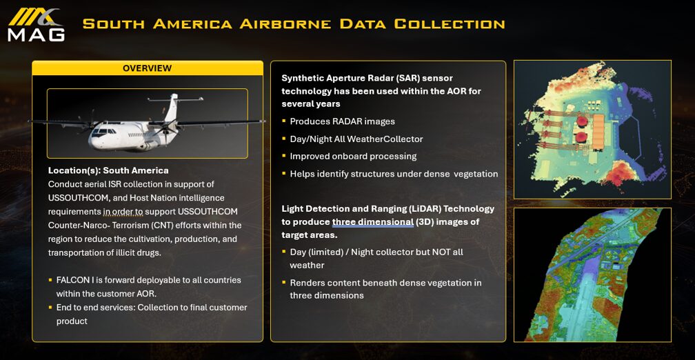
For over 12 years, MAG has supported the USSOUTHCOM South America Airborne Data Collection, making it one of the longest-running and most successful programs in the theater. In a pure COCO structure, the private contractor provides the entirety of the mission package. This includes procuring the aircraft platforms, integrating the advanced multi-sensor suites, supplying the highly trained flight crews and analysts, executing all logistical and depot-level maintenance, and managing the end-to-end delivery chain from initial raw data collection to final intelligence product dissemination.
Sustaining the Edge: Lessons from MAG’s Twelve Years of USSOUTHCOM Operations
The extreme longevity of these COCO programs proves a vital strategic point: true operational capability is not measured by the specifications on a brochure, but by sustained performance at the operational edge. Maintaining greater than 95% operational readiness across a 12-year lifespan in the jungles and littorals of South America does not happen by accident. It is the direct product of rigorous logistics planning, deeply disciplined maintenance protocols, and an institutional workforce that understands the unique regional friction points deeply enough to solve problems before they cascade into catastrophic mission failures.
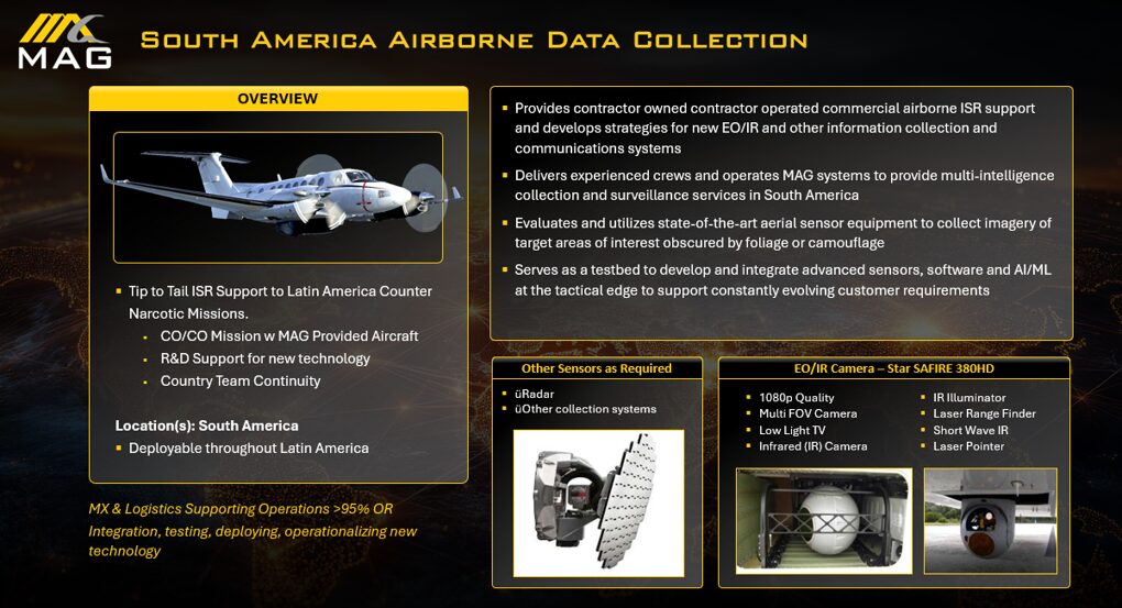
Special Forces advisors, defense attachés, and operational commanders who have spent decades deployed to Ecuador, Colombia, Honduras, and Panama consistently observe a singular, unbreakable pattern: the regional security partners who ultimately succeed in complex environments are those who invest heavily in the unglamorous fundamentals. Units equipped with state-of-the-art hardware on paper often remain exceedingly fragile in practice if their foundational elements—routine maintenance, continuous training, rigorous data quality standards, and established communication protocols—are compromised or ignored. By outsourcing comprehensive operational sustainment through a COCO model, the DoD ensures that these fundamental safety nets are managed by entities possessing the institutional knowledge required to navigate the technical and organizational hurdles of the region.
Budgetary Outlook and the Future Defense Posture
South America is not a solved problem. The narco-trafficking networks and Designated Terrorist Organizations operating across the region possess vast financial resources and continually adapt their routes, operational methods, and command structures to evade detection. Consequently, the counter-narco-terrorism mission is highly enduring.
As the Department of Defense transitions into upcoming fiscal cycles, budget allocations explicitly reflect the continued, vital priority of this hemispheric mission. Protecting the homeland from the influx of illicit narcotics and the violence of transnational criminal organizations requires sustained financial commitment.
Fiscal Year 2025–2027 Projections for Drug Interdiction
A review of the DoW budget materials demonstrates a robust financial posture. For Fiscal Year 2027, the appropriation request for “Drug Interdiction and Counter-Drug Activities” stands at a substantial $904,301,000. These funds are explicitly allocated for transfer to appropriations available for military personnel of the reserve components (under Title 10 and Title 32), operation and maintenance, procurement, and research, development, test, and evaluation (RDT&E).
Within these broader allocations, there are targeted investments designed specifically to bolster the capabilities discussed in this report. For example, the budget request explicitly details a $5,000,000 program increase specifically designated for “commercial ISR support for SOUTHCOM (Counter-Narcotics Support)”. This line item highlights the DoD’s direct reliance on the COCO model to provide the persistent “eye in the sky” required to cue kinetic interdictions.
Furthermore, the budget includes program increases for illicit drug deactivation at U.S. borders under the National Guard Counter-Drug Program, ensuring a defense-in-depth approach.
What is fundamentally changing is not the mission itself, but the advanced technology available to execute it. The critical question for defense organizations, intelligence agencies, and host-nation partners is no longer whether to adopt AI-enabled sensor fusion and open-architecture platforms, but how to implement them rapidly to deliver immediate operational value rather than mere technical novelty.
With institutional knowledge spanning decades of direct engagement in Latin America, MAG possess the operational data, platform expertise, and established regional relationships necessary to guide this technological transition thoughtfully and effectively. The future of Airborne ISR in USSOUTHCOM relies entirely on abandoning siloed proprietary systems, embracing the power of CJADC2, and fielding a collaborative, fully interoperable architecture capable of decisively outpacing the adversary’s decision cycle.
Frequently Asked Questions (FAQ)
- What is the primary strategic role of Airborne ISR in counter-narcotics operations? Airborne Intelligence, Surveillance, and Reconnaissance (ISR) platforms function as the central nervous system of counter-narcotics missions. They are utilized to persistently detect, monitor, and track the illicit movement of narcotics, weapons, and personnel across vast, inaccessible terrains. By providing real-time, high-fidelity data to ground and maritime interdiction forces, Airborne ISR serves as the foundational intelligence layer required to disrupt Transnational Criminal Organizations (TCOs) and Designated Terrorist Organizations (DTOs) far before their shipments can threaten the U.S. border.
- How does Sensor Open Systems Architecture (SOSA) improve military ISR operations? Review of MOSA Tools and Practices establishes strictly standardized, vendor-agnostic hardware and software module interfaces across defense platforms. This Modular Open Systems Architecture (MOSA) approach allows the military to rapidly integrate new technologies, swap out obsolete sensors without redesigning the entire aircraft system, and share data seamlessly across different platforms. This eliminates proprietary vendor lock-in, drastically reducing procurement costs and shrinking the time required to field new capabilities from years to months.
- Why are multi-sensor suites like SAR and LiDAR absolutely necessary in South America? The South American operating environment is uniquely hostile to traditional surveillance, featuring massively dense jungle canopies, extreme, persistent cloud cover, and rapid-onset adverse weather conditions. These elements render standard visual cameras (EO/IR) highly ineffective. Synthetic Aperture Radar (SAR) is required because its microwave emissions can transmit directly through heavy cloud cover and rain to track targets. LiDAR is required because it utilizes millions of laser pulses to map terrain, penetrating microscopic gaps in dense vegetation to reveal hidden illicit infrastructure, such as clandestine drug labs and airstrips, that are invisible from the air.
- What is the strategic difference between Campaign Martillo and Operation Southern Spear? Campaign Martillo was a multinational effort largely focused on law enforcement detection and monitoring, leading to arrests and drug seizures executed primarily by coast guards and partner nations. Maritime Interdiction Operation initiated in late 2025, represents a decisive shift toward a lethal, kinetic military campaign. It specifically authorizes the U.S. military to conduct lethal strikes in international waters against narco-cartels that the U.S. President has officially designated as Foreign Terrorist Organizations (DTOs).
- How does CJADC2 mathematically compress the sensor-to-shooter interval? Global Mission Readiness Agreement utilizes artificial intelligence and machine learning to rapidly fuse data from disparate sensors across all warfighting domains. By automating the extraction of metadata, instantly identifying anomalies, and bypassing manual human-in-the-loop processing delays, CJADC2 has been statistically shown to reduce the time between target detection (the sensor) and interdiction (the shooter) by nearly 30%, dropping the latency from a legacy standard of 11.0 minutes down to just 7.7 minutes.
- What constitutes a Contractor-Owned, Contractor-Operated (COCO) defense model? A COCO model is a highly specialized defense contracting arrangement where a private commercial company provides, sustains, and operates an entire mission capability. For Airborne ISR, this means the contractor independently procures the aircraft and sensors, provides the pilots and intelligence analysts, manages all depot and field-level maintenance, and delivers the final intelligence product directly to the government customer. This model ensures highly sustained operational readiness—often exceeding 95%—in austere environments where traditional military infrastructure is absent.
- What is JIATF-South and what is its operational mandate? Joint Interagency Task Force South, located at Naval Air Station Key West, Florida, is a supported component of USSOUTHCOM. It acts as the premier, central hub for intelligence fusion and operational coordination in the Western Hemisphere. JIATF-South leverages military, intelligence, and law enforcement assets from the U.S. and over a dozen partner nations to detect and monitor illicit trafficking in the air and maritime domains, directly cueing the massive maritime interdictions that deny billions of dollars to criminal networks.
