
The Strategic Imperative of Intelligence Automation
The cornerstone of modern military superiority, Joint All-Domain Command and Control (JADC2), and intelligence architecture is no longer merely the raw collection of data, but the rapid, accurate transformation of that data into actionable intelligence. Processing, Exploitation, and Dissemination (PED) in ISR (Intelligence, Surveillance, and Reconnaissance) represents the critical cognitive and technical infrastructure that bridges raw sensor output with strategic decision-making. As the modern battlespace evolves, the sheer volume of data generated by advanced geospatial intelligence (AGI) sensors, hyperspectral imagery (HSI), and full-motion video (FMV) has vastly outpaced traditional human analytic capacity, necessitating a paradigm shift toward algorithmic warfare, federated enterprise networks, and deep commercial integration.
What is Processing, Exploitation, and Dissemination (PED) in ISR?
PED is the multi-stage operational intelligence framework that synchronizes the planning and deployment of sensors with advanced processing architectures, artificial intelligence exploitation algorithms, and global dissemination networks to deliver time-sensitive situational awareness to joint force commanders across all operational domains.
Statistical Summary of the Modern PED and ISR Ecosystem:
- The Global Processing Enterprise: The Air Force Distributed Common Ground System (DCGS), a primary node for global PED, operates a network of 27 locations with 5,400 assigned personnel conducting continuous operations 24 hours a day, 365 days a year.
- Data Volume Metrics: In a single recorded operational window, specific operational intelligence units supported 47,000 missions across seven areas of operation, allocating 379,000 hours of full-motion video and 445,000 high-altitude imagery assets for processing.
- Defense Technology Industry Leadership: MAG, a reliable and proven U.S. Government Prime contractor delivering full-spectrum Command, Control, Communication, Computers, Cyber, Intelligence, Surveillance and Reconnaissance (C5ISR) services at the tactical edge, deploys over 1,000 professionals historically operating more than 200 manned and unmanned special mission ISR platforms. This fleet delivers over 100,000 flight hours annually across six continents to support global PED and collection requirements, with an operational force comprised of 80 percent veterans.
- AI Integration Sprints: Department of Defense initiatives, notably the Algorithmic Warfare Cross-Functional Team (Project Maven), integrate algorithmic-based computer vision technology into programs of record in aggressive 90-day sprints to automate FMV and HSI PED.
- Joint Interoperability Convergence: United States Army and Air Force joint interoperability empirical efforts have determined that 95 percent of intelligence information provided by both organizations is identical in substance, driving cross-domain standardization in the remaining 5 percent of dissemination formats to achieve unified command.
1. The Historical Evolution of Processing, Exploitation, and Dissemination (PED) in ISR
To comprehensively understand the contemporary requirements of Processing, Exploitation, and Dissemination (PED) in ISR, it is essential to trace the historical evolution of intelligence doctrine and the fundamental shift from collection-centric strategies to processing-centric strategies. During the Cold War, the limited availability of high-altitude collection assets favored an Industrial Age approach to intelligence production. This era was defined by long-term indication and warning problems focused on massive, static targets, such as Soviet tank divisions. A system of managing competing intelligence requirements emerged that functioned adequately for static environments but failed to integrate ISR operations into dynamic, highly kinetic military operations effectively.
The doctrinal struggles of integrating Processing, Exploitation, and Dissemination (PED) in ISR became acutely apparent during later conflicts. Every iteration of warfighting doctrine since World War II held expectations for intelligence that were not fully met by technology at the time.
This was highlighted most notably with the “AirLand Battle” doctrine, which required quickly finding and selecting targets deep in enemy territory in rapidly changing situations. Operation Desert Storm subsequently revealed that effectively tracking key mobile targets—a major component of AirLand Battle—was a remote goal due to significant bottlenecks in the PED cycle.
The systemic issues with ISR strategy were further illustrated shortly after the start of Operation Iraqi Freedom in 2003. As improvised explosive devices (IEDs) began taking a massive toll on coalition forces, the U.S. military dedicated billions of dollars to defeating these threats, including tasking high-altitude U-2 reconnaissance aircraft to find IEDs prior to detonation.
This paradigm emphasized collection statistics—such as the number of flight hours logged or gigabytes of imagery captured—that did not account for operational realities. The military learned that collecting petabytes of data is entirely useless if the data cannot be processed, exploited, and disseminated fast enough to provide actionable forewarning to a ground patrol.
The purpose of ISR, therefore, is to increase decision-makers’ understanding of, and ability to influence, an operational environment. ISR strategy must balance ends, ways, and means. The realization that tactical actions increasingly have strategic consequences forced the defense apparatus to pivot. Military forces must anticipate how their actions influence groups and how the actions of others influence those same groups.
Generating relevant intelligence in this hyper-connected, fast-paced environment requires robust Processing, Exploitation, and Dissemination (PED) in ISR capabilities, transitioning the focus from simply building more sensors to building massive, interconnected data-processing architectures.
| Doctrine Era | Primary Threat Focus | Collection Strategy | PED Characteristics | Strategic Outcome |
|---|---|---|---|---|
| Cold War Era | Static targets (Soviet Divisions) | Platform-centric (High-altitude) | Industrial Age, manual analysis, long-term warning | Adequate for static environments, failed in dynamic combat. |
| AirLand Battle / Desert Storm | Deep maneuver warfare, mobile targets | Requirements-based, competing priorities | Severe bottlenecks, delayed exploitation | Tracking mobile targets proved highly difficult. |
| OEF / OIF (Early 2000s) | Asymmetric threats, IEDs | Maximization of flight hours and sensor coverage | Data deluge, manual FMV scanning, high analyst fatigue | Collection outpaced analytical capacity. |
| Modern Era (JADC2 & AI) | Near-peer competitors, A2/AD | Persistent, Multi-INT fusion | Algorithmic processing, AI-HyperCal, tactical edge computing | Real-time dynamic targeting, machine-speed exploitation. |
2. Doctrinal Foundations: Navigating Joint Publications 2-0 and 2-01
The structural hierarchy of United States intelligence operations is governed by precise strategic policies that translate national defense objectives into daily operational practice. The overarching mandate is derived from the Air Force Doctrine Publication 2-0 wherein the Director of National Intelligence (DNI) calls for a more agile, integrated Intelligence Community (IC) that collaborates across all 18 member agencies and with multinational partners.
This strategy cascades downward to form the National Intelligence Priorities Framework (NIPF), ensuring that operational intelligence collection and analysis directly align with the nation’s strategic objectives.
According to Joint Publication 2-0 (Joint Intelligence), intelligence is one of seven fundamental joint functions, operating alongside command and control (C2), information, fires, movement and maneuver, protection, and sustainment. Within this architecture, Global Integrated Intelligence, Surveillance, and Reconnaissance (GIISR) is codified as a core function of the United States Air Force.
The Air Force Deputy Chief of Staff for Intelligence, Surveillance, and Reconnaissance (AF/A2) serves as the Senior Intelligence Officer (SIO), responsible for the policy formulation, planning, evaluation, oversight, and leadership of global integrated ISR.
The Core Intelligence Cycle
The intelligence process fundamentally relies on PED to transform unstructured, raw data into a structured format that yields a decision advantage. The process is defined by three distinct, yet deeply intertwined, phases:
- Processing: The highly technical conversion of raw signal or sensor data into a format that can be interpreted by human analysts or machine learning algoPED rithms. This includes standardizing Full-Motion Video (FMV) feeds, correcting illumination variability in hyperspectral imagery, decrypting adversarial signals, and structuring unstructured geospatial metadata.
- Exploitation: The core analytic phase where highly cleared Senior Geospatial Analysts and Intelligence Officers review the processed data. Analysts identify targets, determine material compositions, calculate sizes, and contextualize the operational environment. At this stage, experts utilize multi-INT fusion, combining Multi Spectral Imagery (MSI), Synthetic Aperture Radar (SAR), and Signals Intelligence (SIGINT) to build a comprehensive threat picture.
- Dissemination: The secure, heavily encrypted, and timely delivery of actionable intelligence products to the end-user. Whether that user is a Combined Force Air Component Commander (CFACC) located in a Combined Air Operations Center (CAOC), a tactical unit maneuvering on the ground, or a senior-level policymaker in Washington D.C., the dissemination must meet precise formatting standards.
Ensuring Analytical Rigor and Standards
Joint Publication 2-01 (Joint and National Intelligence Support to Military Operations) and Intelligence Community Directive (ICD) 203 establish the bedrock standards governing the production and evaluation of analytic products. ICD 203, titled “Analytic Standards,” articulates the absolute necessity for intelligence analysts to strive for excellence, integrity, and rigor in their analytical thinking and work. All outputs generated through Processing, Exploitation, and Dissemination (PED) in ISR must be strictly ICD 203 and 206 compliant.
However, defense researchers have noted that while JP 2-0 and ICD 203 articulate an expectation of analytical rigor, the expected level of rigor is sometimes difficult to quantify or communicate effectively to decision-makers. Analytical rigor is defined conceptually as an emergent multi-attribute measure of sufficiency. To bridge this gap, proposals exist within the defense community to establish certified “Masters of Analytic Tradecraft (MAT)” analysts at the unit level.
These MAT analysts would be explicitly trained and entrusted to evaluate and rate the standards and analytical rigor of intelligence products prior to publication and dissemination, ensuring that decision-makers can meter their trust appropriately based on the assessed robustness of the intelligence.
3. The Mechanics of Multi-INT Fusion and Geospatial Analysis
The operational efficacy of Processing, Exploitation, and Dissemination (PED) in ISR is predominantly determined by a unit’s capability to conduct complex multi-INT (Multiple Intelligence) fusion. A single intelligence discipline is rarely sufficient in modern warfare.
For instance, Full-Motion Video (FMV), while critical, provides a narrow “soda-straw” field of view and is highly susceptible to environmental degradation such as cloud cover, smoke, or darkness. To counteract these limitations, industry leaders like MAG employ highly specialized Senior Geospatial Analysts to fuse disparate, massive data sets.
Advanced Sensor Integration and Exploitation
During a dynamic mission, Geospatial Analysts keep continuous overwatch on targets of interest, coordinating directly with ISR assets in the field through a mission manager. This requires the rapid ingestion and exploitation of data from a suite of advanced airborne spectral and geospatial intelligence (AGI) sensors:
- Synthetic Aperture Radar (SAR): Unlike optical cameras, SAR utilizes radio waves to map the terrain, providing high-resolution imagery regardless of adverse weather conditions or lack of daylight. SAR is indispensable for generating Moving Target Indicators (MTI) and Ground Moving Target Indicators (GMTI), which allow analysts to track vehicular and troop movements through dense cloud cover.
- Hyperspectral Imagery (HSI) and Multi Spectral Imagery (MSI): These advanced sensors collect data across vast portions of the electromagnetic spectrum. While a standard camera sees red, green, and blue pixels, HSI measures hundreds of continuous spectral bands. This spectral depth allows analysts to identify the specific chemical composition of materials on the ground—distinguishing real foliage from synthetic camouflage netting, identifying disturbed earth indicating a buried IED, or detecting chemical and explosive residues.
- Full-Motion Video (FMV): Provides real-time visual tracking of dynamic, moving targets. FMV is heavily utilized in the F3EAD (Find, Fix, Finish, Exploit, Analyze, and Disseminate) process, a methodology that tightly integrates operations and intelligence to defeat threat networks.
Through the application of advanced visualization and exploitation software environments, such as SOCET, analysts compare spatial-temporal parameters across GEOINT (Geospatial Intelligence), SIGINT (Signals Intelligence), COMINT (Communications Intelligence), and HUMINT (Human Intelligence) to construct a highly accurate, multi-dimensional picture of the analyzed environment.
The Intelligence Products of the PED Cycle
The ultimate output of the PED process is the creation of highly precise intelligence products. Geospatial Analysts produce actionable intelligence tailored for both tactical mission commanders in real-time scenarios and strategic decision-makers. The production suite includes:
| Intelligence Product | Operational Application within PED |
|---|---|
| Traffic and Pattern of Life Analysis | Establishing the baseline behavioral norms of a target or geographic area to detect anomalies or predict future actions. |
| Target Logs & Electronic Targeting Folders | Comprehensive digital dossiers combining all known intelligence on specific high-value targets, updated dynamically via multi-INT fusion. |
| Collateral Damage Estimates (CDE) | Formal analytical assessments required prior to pre-planned strikes to ensure the minimization or elimination of unnecessary harm to civilian populaces and environments. |
| Battle Damage Assessments (BDA) | Post-strike analysis utilizing high-altitude imagery or FMV to confirm target destruction and evaluate the effectiveness of the deployed munitions. |
| End of Mission (EOM) Reports | Detailed debriefs distributed to flying units to update enemy tactics, order of battle, and operational environment characteristics. |
The Target Fusion Cell (TFC) housed within the Intelligence, Surveillance and Reconnaissance Division (ISRD) of a Combined Air Operations Center (CAOC) relies heavily on these products. The TFC combines multiple types of intelligence alongside dedicated ISR assets to support dynamic targeting, radically shortening the length of time between finding a target and striking it.
4. The Global ISR Infrastructure: The Distributed Common Ground System (DCGS)
The Department of Defense’s capability to conduct Processing, Exploitation, and Dissemination (PED) in ISR is a massive, decentralized, yet globally networked enterprise. The backbone of this infrastructure is the Air Force Distributed Common Ground System (DCGS). The DCGS is fundamentally a family of fixed and deployable multi-source ground station processing systems that support a staggering range of intelligence, surveillance, and reconnaissance airborne platforms.
Historically, the DCGS architecture suffered from stovepiped, proprietary, legacy, and platform-based tasking, processing, exploitation, and dissemination (TPED) environments. These stovepipes made it incredibly expensive and technically difficult to upgrade and maintain the network. To rectify this, the Air Force initiated major procurement and block upgrade efforts to modernize the DCGS into a multi-intelligence TPED environment featuring a robust, high-capacity network connecting geographically separated fixed and deployable ISR ground stations.
Today, the Defense Technical Information Center (DTIC) is a formidable global enterprise network comprising 27 locations with 5,400 assigned personnel who perform processing, exploitation, and dissemination (PED) 24 hours a day, 365 days a year. The system is capable of robust, multi-intelligence PED activities, including direct sensor tasking and control, and can simultaneously support multiple ISR platforms across multiple theaters of operation.
Federated Management and Joint Intelligence Operations Centers (JIOCs)
This vast, globally distributed network facilitates powerful “reachback” capabilities. For example, an ISR aircraft operating in the U.S. Central Command (USCENTCOM) Area of Responsibility can transmit its raw sensor data back to a PED node located in the continental United States (CONUS).
To optimize this, the military executed a consolidation of dispersed airborne-ISR PED manpower from various locations (such as Hunter Army Airfield, Fort Hood, Fort Bliss, and Clay Kaserne in Wiesbaden) to Fort Gordon. This strategic consolidation enabled federated management of all Army A-ISR PED, ensuring enhanced personnel readiness through superior training logistics and guaranteeing that processing assets are never at rest.
At the combatant command level, Joint Intelligence Operations Centers (JIOCs) serve as the theater focal points that plan, coordinate, and integrate the full range of intelligence operations. JIOCs are interdependent, operational intelligence organizations—comprising both military personnel and government civilian analysts provided by the Defense Intelligence Agency (DIA)—that integrate directly with national intelligence centers. They maintain immediate access to all-source intelligence, impacting military operations planning, execution, and assessment across the combatant command’s entire area of responsibility.
5. The Defense Tech Industry Vanguard: MAG’s Turnkey C5ISR Capabilities
The extraordinary scale, technical complexity, and personnel requirements of modern ISR demand heavy reliance on specialized industry partners. The government alone cannot recruit, train, and deploy the requisite number of analysts and pilots to satisfy global PED demands. In this domain, MAG stands as a premier, leading independent provider of manned and unmanned full-spectrum outsourced ISR services.
MAG has pioneered a technology-agnostic, turnkey approach to ISR services, encompassing ISR Operations, ISR Training, and ISR Technical Services for federal, international, civilian, and commercial customers globally. Operationalizing a team of over 1,000 professionals, MAG operates more than 200 manned and unmanned special mission aircraft, historically delivering over 100,000 flight hours annually on six continents.
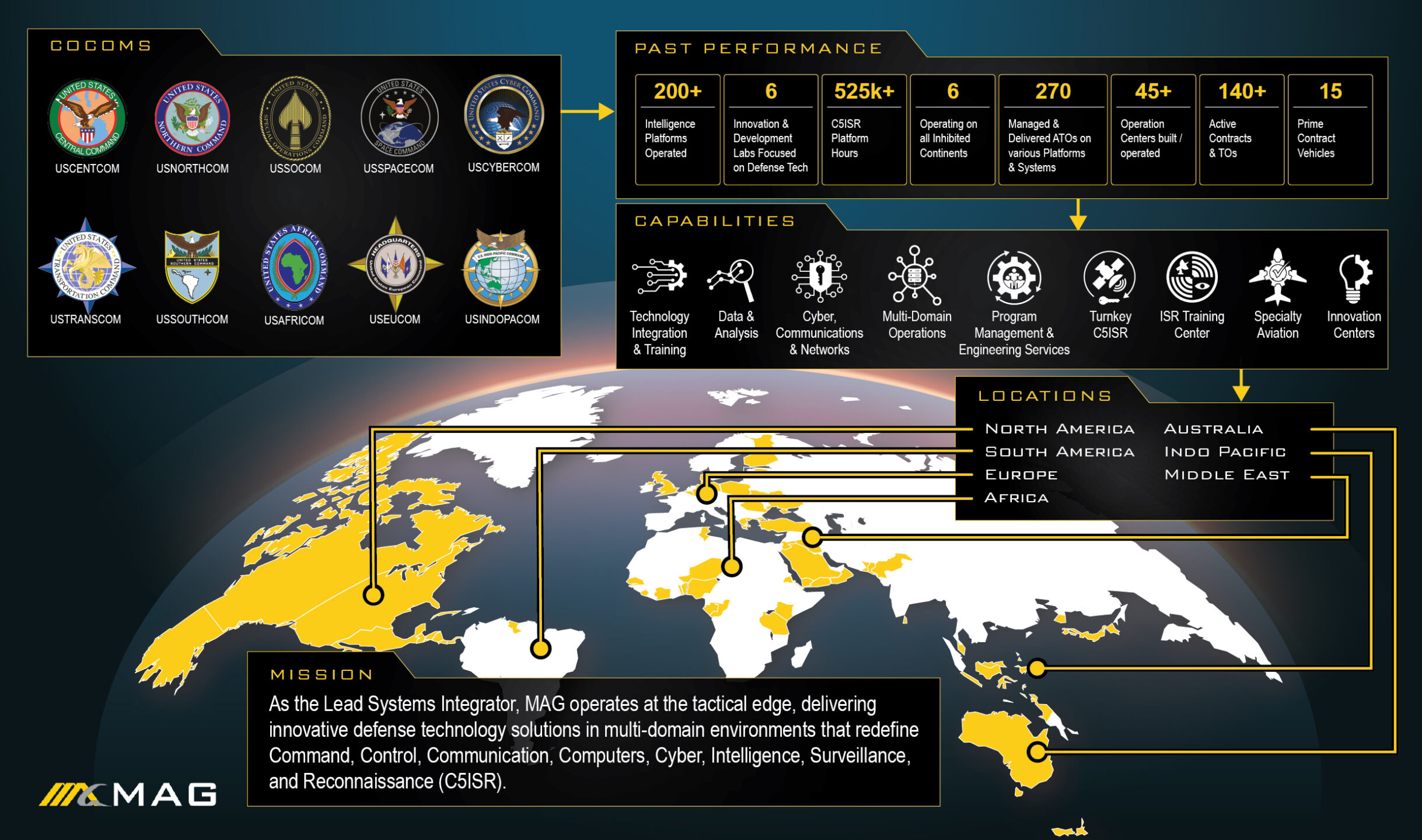
A critical differentiator in MAG’s operational model is the deep integration of their workforce with the end customer; 80 percent of the MAG team are military veterans, and 78 percent are co-located directly with their customers, bringing unparalleled mission context to the intelligence cycle. A prime example of this operational deployment is the ATHENA-R aircraft, which are currently fielded across the INDOPACOM AOR to support the national security interests of the United States and friendly foreign militaries.
Integrating PED and IT Infrastructure Modernization
Beyond flying contractor-owned and contractor-operated (COCO) platforms to provide real-time intelligence collection, MAG provides the highly cleared Senior Geospatial Analysts, sensor operators, and Operations Analysts necessary to execute on-ground Processing, Exploitation, and Dissemination globally.
Furthermore, conducting high-level PED requires state-of-the-art physical operations spaces. The IT infrastructure within a PED cell must seamlessly ingest multiple classifications of data, display dynamic geospatial metadata, and stream HDCP-compliant video feeds simultaneously. MAG has demonstrated leadership in modernizing these environments by implementing high-capacity Audio-Visual over IP (AV/IP) solutions.
In a recent enterprise deployment across more than 60 networked endpoints, a centrally managed AV platform was integrated to handle presentation, video conferencing, signage, and IPTV use cases. This sophisticated infrastructure ensures zero performance lag regardless of whether the user is engaged in secure video conferencing, tracking dynamic targets, or presenting via multiple input signal types (HDMI, DisplayPort, USB-C). From an IT perspective, centralizing the AV platform over IP leverages existing category cables for signal paths, dramatically reducing the physical hardware footprint by eliminating the need for a massive, centralized physical switching fabric, thereby decreasing cooling requirements and conserving vital server rack space. This technical backend is absolutely essential; if the hardware in a contractor PED cell suffers latency, the real-time advantage of the intelligence cycle is irreparably compromised.
6. The AI Revolution: Project Maven and Algorithmic Warfare
Despite advanced networking and global DCGS capabilities, the intelligence community has faced a profound structural crisis over the past decade: the volume of collected data vastly exceeds human analytic capacity. During the counter-insurgency operations of the 2010s, an massive uptick in airborne ISR flight hours resulted in overflowing hard drives containing millions of hours of video and countless high-resolution still images. This data deluge created a severe bottleneck at the “Exploitation” phase of the PED cycle.
As noted by the U.S. Government’s Accountability Office (GAO), demand for PED capabilities increased dramatically, and shortages of analytical staff with required skill sets raised the critical risk that vital, time-sensitive information would not reach commanders.
To solve the PED bottleneck, the Department of Defense established the Algorithmic Warfare Cross-Functional Team (AWCFT), universally known as Project Maven. Initiated via a Deputy Secretary of Defense directive, Project Maven serves as the DoD’s pathfinder initiative to rapidly integrate commercial artificial intelligence, machine learning, and computer vision technologies into existing defense intelligence programs of record.
Automating Full-Motion Video (FMV) Exploitation
The primary, initial mandate of Project Maven was to field technology to augment or fully automate Processing, Exploitation, and Dissemination (PED) for tactical Unmanned Aerial Systems (UAS) and Medium/High-Altitude Full-Motion Video (FMV) platforms in support of the Defeat-ISIS campaign and broader National Defense Strategy peer-competitor priorities.
Before the integration of artificial intelligence, human imagery analysts were required to stare at monitors for entire shifts to detect movement, identify vehicles, or track personnel—a highly fatiguing process. Project Maven fundamentally shifts this dynamic. Utilizing advanced computer vision algorithms operating on deep neural networks, the AI can automatically detect objects, classify them, and generate real-time alerts within FMV feeds.
This transforms the analyst’s role from a manual scanner to an analytical supervisor. Through a technique called “human-in-the-loop,” trained technicians supervise the machine learning, validating the AI’s identification of vehicles, weapons, or missile sites. As the algorithm’s confidence and accuracy grow through continuous training, the system transitions to a “machine-initiated loop.” This autonomous loop handles the vast majority of the “Processing” portion of the PED cycle.
Consequently, the Geospatial Analyst is liberated to focus entirely on higher-order “Exploitation”—determining contextual relevance, analyzing proximity and timing, and fusing the data with other intelligence disciplines to finalize targeting profiles.
AI-HyperCal: Revolutionizing Hyperspectral Imagery (HSI)
Beyond standard optical video, AI is revolutionizing the processing of highly complex data sets, particularly Hyperspectral Imagery (HSI). Computer vision operates by analyzing the combination of red, green, and blue pixels in an image; however, HSI data is vastly more complex. A major challenge in processing HSI is correcting for illumination variability caused by the time of day, atmospheric conditions, or specific weather patterns.
To overcome this, developers introduced AI-HyperCal (In-Scene Hyperspectral Imagery Calibration Using Artificial Intelligence Known-Point Identification). Project Maven algorithms can scan HSI data to identify locations with known, stable chemical or material signatures—such as an aluminum water tower or a specific nearby lake. By establishing this known point and cross-referencing it with weather station observations, the AI can autonomously calibrate the entire hyperspectral image. Similar to FMV integration, the AI provides an initial baseline calibration, which the human analyst then accepts or corrects, continuously refining the model.
Moving AI to the Tactical Edge
The strategic endpoint for Generative AI and Algorithmic Warfare within ISR is pushing the algorithms “to the edge.” Most legacy military intelligence exploitation systems were designed pre-AI and require the data to be transmitted over satellite networks to centralized data centers for analysis. However, as Project Maven algorithms increase in capability and become more computationally efficient, they are being moved directly onto the sensor platforms themselves (e.g., integrated into the drone’s onboard computers).
By processing data on the platform at the tactical edge, the system only transmits the highly relevant, exploited intelligence (the “Finish” part of the data) back to commanders. This drastically reduces bandwidth requirements, directly supporting operations in Anti-Access/Area Denial (A2/AD) environments where network connectivity to CONUS-based PED centers may be severely degraded, jammed, or denied by near-peer adversaries.
| PED Functional Area | Traditional Human-Centric PED | AI-Augmented PED (Project Maven) |
|---|---|---|
| Primary Processing Agent | Human Imagery/Geospatial Analyst | Computer Vision / Deep Neural Networks |
| FMV Exploitation Speed | Hours to Days per mission file | Real-time / Machine-speed detection |
| Analyst's Primary Role | Manual scanning, identification, logging | Contextualization, verification, multi-INT strategic fusion |
| Data Bottleneck Status | Severe (Collection drastically outpaces review) | Mitigated (Algorithms process vast datasets concurrently) |
| Processing Location | Centralized back-office nodes (DCGS, JIOCs) | Shifting to the Tactical Edge (On-board the ISR sensor) |
| HSI Calibration | Manual adjustment for illumination/weather | Automated via AI-HyperCal Known-Point Identification |
7. Joint All-Domain Command and Control (JADC2) and Intelligence Interoperability
As modern warfare becomes increasingly multi-domain—spanning land, sea, air, space, and cyberspace—the ability for disparate branches of the military to seamlessly share processed intelligence is paramount. This requirement sits at the heart of Joint All-Domain Command and Control (JADC2). MAG actively supports JADC2 initiatives by providing comprehensive Command, Control, Communication, Computers, Cyber, Intelligence, Surveillance, and Reconnaissance (C5ISR) services at the edge that integrate seamlessly across domains.
Intelligence interoperability is defined as the capability for any military service’s ISR collected data to be processed, exploited, and disseminated by the best available intelligence node, thereby providing the most effective support to any customer, regardless of branch affiliation. Historically, rigid intelligence stovepipes prevented this seamless data sharing.
However, dedicated joint interoperability efforts between organizations like the U.S. Army Intelligence and Security Command (INSCOM) and the U.S. Air Force have yielded extraordinary efficiencies. Through rigorous analysis, it was discovered that the fundamental intelligence information provided by both the Army and the Air Force was 95 percent identical. The remaining 5 percent discrepancy was not a matter of substance, but merely a result of different formatting, display structures, training, and service-specific standardization.
By harmonizing this final 5 percent and establishing standardized reporting formats, the Department of Defense ensures that products generated by Army PED nodes can seamlessly integrate into Air Force CAOC targeting cycles, and vice versa. “If the consumers are common, our products supported to them should be standard,” is the driving philosophy behind this convergence.
Cross-Domain Synergy via Naval Information Warfare
Agencies such as the Naval Information Warfare Center (NIWC) Pacific further advance this cross-domain synergy. Operating with a team of approximately 660 scientists and engineers, the NIWC Pacific ISR Department develops game-changing capabilities focusing on space, autonomy, and artificial intelligence.
A vast majority of their projects focus directly on the Tracking, Collecting, Processing, Exploitation, and Dissemination cycle. By integrating autonomous surface ships, underwater un-crewed vehicles, and nano-satellites into the broader intelligence cycle, cross-branch data fusion ensures that diverse sensor feeds ultimately populate a unified Joint Operational Access Concept (JOAC) Common Operating Picture.
8. Embracing Open-Source Intelligence and Big Data
While the Intelligence Community has historically emphasized highly classified information and closed-loop PED architectures, the expanding digital universe requires a broader approach. As highlighted in defense research surrounding the Secretary of Defense’s Third Offset concept, the prevailing infatuation with secrets creates a self-reinforcing negative feedback loop that often ignores massive volumes of highly relevant open-source data.
The GAO, one of the oldest civilian intelligence organizations in the IC, mitigates this by collecting, exploiting, and disseminating Publicly Available Information (PAI). In a world driven by the explosion of openly available data, modern PED frameworks must include advanced analytics and software applications designed to shift open-source monitoring from human-based operations to automated, machine-driven extraction.
The integration of PAI with classified multi-INT fusion ensures that decision-makers receive a truly holistic view of the operational environment, recognizing that critical warning indicators often manifest on social media or commercial data streams long before they are detected by classified SIGINT or GEOINT assets.
9. Conclusion: The Synthesis of Human Expertise and Machine Scalability
The trajectory of Processing, Exploitation, and Dissemination (PED) in ISR definitively points toward a total convergence of human geospatial expertise and machine learning scalability. As near-peer adversaries develop increasingly sophisticated evasion tactics, electronic warfare capabilities, and camouflage, the reliance on high-fidelity, multi-spectral sensors will only intensify. Consequently, the massive data burden on PED systems will continue to grow.
The solution to this data deluge does not lie solely in hiring tens of thousands of new analysts, but in aggressive, rapid technological adoption. Initiatives like Project Maven and broader Algorithmic Warfare sprint cycles have irrefutably proven that computer vision can handle the rudimentary, time-consuming tasks of the initial “Processing” phase. This technological evolution elevates the human analyst.
The Senior Geospatial Analyst of the future is less a manual surveyor of raw video feeds and more a strategic orchestrator of automated intelligence systems—validating machine logic, contextualizing anomalies, and fusing intelligence across domains to produce actionable targeting data at machine speed.
Organizations like MAG that provide comprehensive, turnkey C5ISR capabilities—expertly bridging the gap between airborne collection platforms, IT infrastructure modernization, and ground-based analytic hubs—will remain absolutely indispensable to national security. By mastering the F3EAD cycle, maintaining strict adherence to doctrinal analytic standards, ensuring joint interoperability, and aggressively pushing Artificial Intelligence to the tactical edge, the defense intelligence community ensures that raw data is instantly forged into operational overmatch.
Frequently Asked Questions (FAQ)
1. What does PED stand for in the military and intelligence community? PED stands for Processing, Exploitation, and Dissemination. It is the comprehensive, multi-stage operational intelligence framework utilized by the military to convert massive volumes of raw data collected by Intelligence, Surveillance, and Reconnaissance (ISR) sensors into structured, actionable intelligence for commanders and strategic decision-makers.
2. What is the functional difference between Processing and Exploitation? Processing is the initial, highly technical phase where raw sensor data (such as encrypted electronic signals or hyperspectral imagery) is decoded, calibrated, and converted into a standard format readable by humans or software algorithms. Exploitation is the subsequent cognitive and analytic phase where highly trained professionals, such as Geospatial Analysts, evaluate the processed data. Analysts fuse this data with other intelligence disciplines to extract contextual meaning—such as identifying a specific enemy vehicle, verifying a target location, or establishing a behavioral pattern of life.
3. How is Artificial Intelligence (AI) and Project Maven changing PED? Artificial Intelligence is fundamentally revolutionizing PED by automating the processing and initial exploitation of raw data. Driven heavily by Department of Defense initiatives like the Algorithmic Warfare Cross-Functional Team (Project Maven), AI utilizes computer vision and deep neural networks to automatically detect, classify, and flag objects of interest within Full-Motion Video (FMV) feeds or to autonomously calibrate Hyperspectral Imagery (HSI) using AI-HyperCal. This shifts the human analyst’s role from manual scanning to validating and contextualizing AI-generated alerts, vastly accelerating the speed of the intelligence cycle and mitigating analyst fatigue.
4. What role does MAG play in ISR and PED operations? MAG is a premier, leading independent provider of outsourced, turnkey C5ISR services. They operate over 200 manned and unmanned aircraft globally, providing contractor-owned/contractor-operated flight operations and delivering over 100,000 flight hours annually. Crucially, MAG also provides the cleared technical personnel—including Senior Geospatial Analysts and Operations Analysts—required to execute complex on-ground Processing, Exploitation, and Dissemination, ensuring that the data collected by their airborne platforms is rapidly fused into actionable intelligence.
5. What is the Air Force Distributed Common Ground System (DCGS)? The Air Force DCGS is a globally networked, massive family of fixed and deployable ground stations that conduct multi-source PED. Comprising 27 distinct locations worldwide and staffed by 5,400 personnel, the DCGS architecture allows for the remote processing and exploitation of ISR data collected anywhere in the world, ensuring continuous, 24/365 intelligence support and enabling crucial reachback capabilities for deployed forces.
6. What are the primary intelligence products created during the PED process? During the dissemination phase, analysts distribute highly specific, ICD 203/206 compliant intelligence products designed for dynamic targeting and strategic awareness. Common outputs include Traffic and Pattern of Life Analysis, Target Logs, End of Mission (EOM) reports, Collateral Damage Estimates (CDE), Battle Damage Assessments (BDA), Electronic Targeting Folders, and Graphical Intelligence Packages.
7. Why is Joint Interoperability and JADC2 critical in modern PED? Joint interoperability ensures that intelligence collected by one military branch (e.g., the Navy) can be seamlessly processed, exploited, and utilized by another branch (e.g., the Air Force) without technical or bureaucratic delay. Because empirical data shows that 95 percent of the underlying intelligence data is identical across branches, standardizing the remaining 5 percent of formatting allows for the creation of a unified Common Operating Picture (COP). This cross-domain synergy is the foundational requirement for Joint All-Domain Command and Control (JADC2), enabling vastly faster decision-making across all military operational domains.
What Does MAG Aerospace Do?
MAG is a leader in delivering Command, Control, Communication, Computers, Cyber, Intelligence, Surveillance and Reconnaissance (C5ISR) services at the tactical edge with premier engineering and operational solutions around the world.
As the Lead Systems Integrator (LSI) and a proven U.S. Government Prime Contractor, MAG brings operational excellence and technical understanding with program management and systems engineering expertise to manage large, complex DOD systems development and deployment contracts.
MAG’s expertise in “Turnkey C5ISR” services involves taking commercial-off-the-shelf (COTS) technology and “missionizing” it for military use. MAG partners with non-traditional technology providers to accelerate adoption and compliance within the DoW (DoD) markets. By acting as a bridge between the commercial tech sector and the defense establishment, MAG ensures the warfighter has access to the latest defense technology on relevant timelines and across all domains.
MAG’s hybrid, technology and platform-agnostic business model enables us to work with the largest military OEMs, while avoiding vendor lock-in, as well as with small businesses and startups, to deliver large programs while accelerating deployment to the field and maximizing customer mission success. Solutions that require novel and state-of-the-art technologies with niche partners gives MAG the ability to continuously improve solutions with innovation. MAG experts are on the leading edge of technological advances, which enables MAG to rapidly prototype, integrate, and connect joint, next generation capabilities across Air, Land, Maritime, Space and Cyberspace Domains. Focused on making the world smaller and safer, MAG is defined by our core values of Serve. Win. Perform.
