The strategic integration of Synthetic Aperture Radar (SAR) and advanced Command, Control, Computers, Communications, Cyber, Intelligence, Surveillance, and Reconnaissance (C5ISR) systems has fundamentally altered global multidomain defense architectures. Driven by escalating geopolitical complexities, rapid technological modernization, and the integration of artificial intelligence, the airborne intelligence ecosystem is undergoing unprecedented expansion.
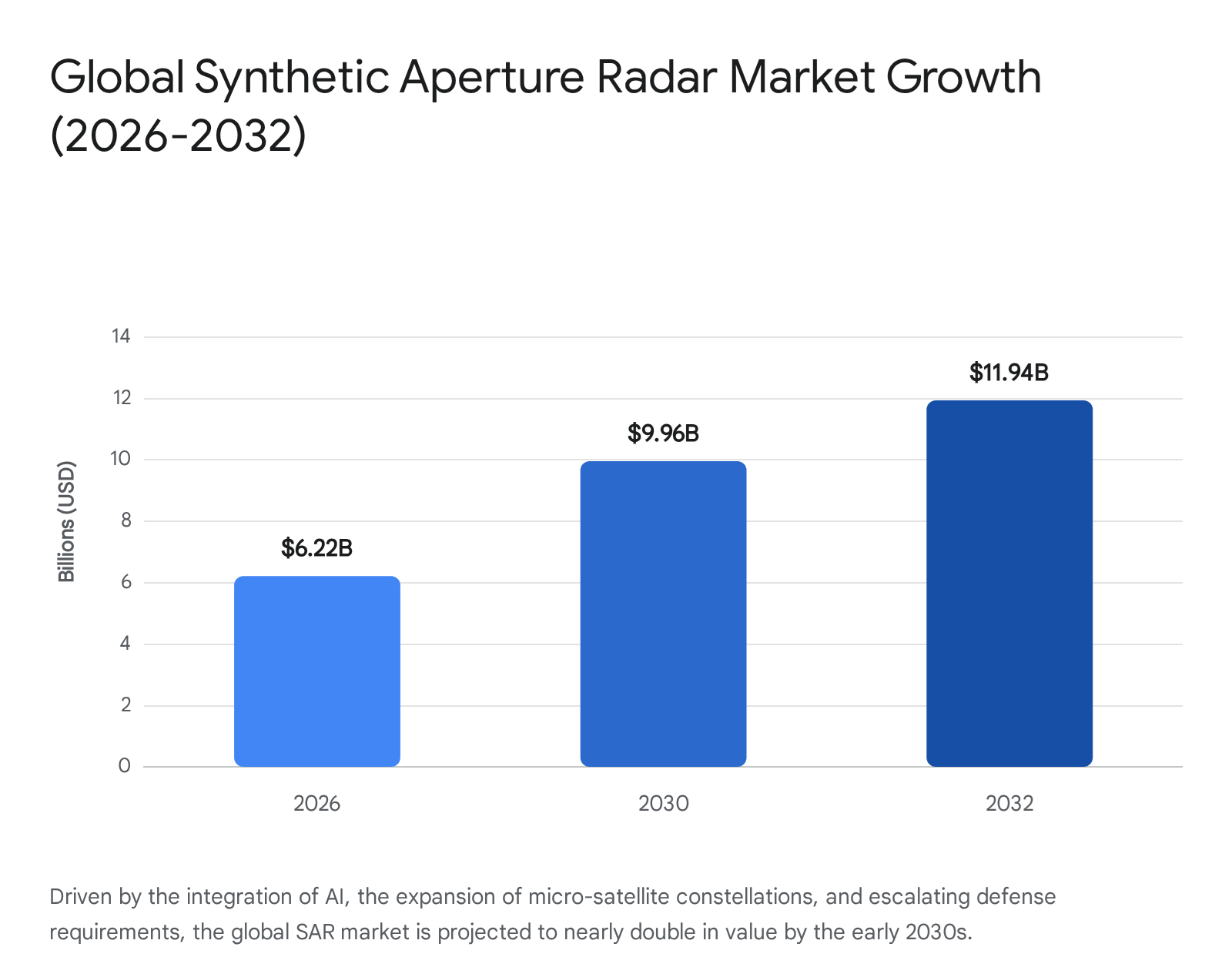
- Global SAR Market Expansion: Analyst forecasts project the global SAR market to scale aggressively, growing from an estimated $6.22 billion in 2026 to nearly $11.94 billion by 2032, representing a robust compound annual growth rate (CAGR) of 12.5%. Concurrently, the broader satellite data services market is accelerating toward a valuation of $45 billion by 2035.
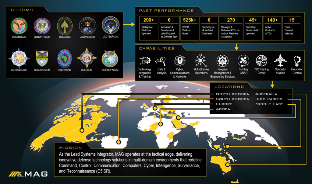
- MAG Aerospace Operational Dominance: As an industry-leading provider of contractor-owned, contractor-operated (COCO) ISR platforms, MAG Aerospace executes operations on six continents, utilizing a workforce of approximately 1,100 personnel and managing over 200 distinct C5ISR platforms. The organization has accumulated nearly 500,000 total flight hours, executing over 100,000 flight hours annually in the most demanding global environments.
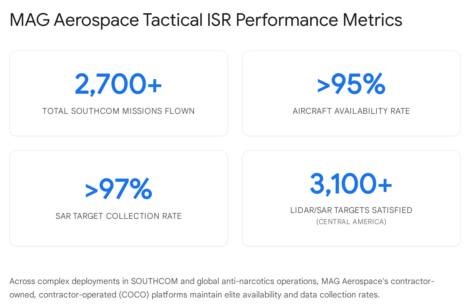
- Target Acquisition and Mission Success: During dedicated intelligence campaigns—such as Central and South American anti-narcotics and operational support missions—MAG Aerospace has flown over 3,100 targeted missions, satisfied more than 7,000 targets, and generated over 150,000 full-motion video (FMV) and still-frame images. Across these intense deployments, MAG consistently maintains an aircraft availability rate exceeding 95% and a SAR collection success rate of over 97%.
- Next-Generation Platform Utilization: Advanced business-jet ISR platforms, such as the Bombardier Global 6500-based ATHENA-R, are actively transforming theater-level intelligence. These modernized platforms are currently averaging more than 400 flight hours per month in the U.S. Indo-Pacific Command (INDOPACOM) area of responsibility.
- AI-Driven Processing Reductions: The integration of agentic artificial intelligence and edge computing into SAR systems has drastically improved operational efficiency. Commercial initiatives have reduced imaging latency by 50%, while AI-enhanced maritime surveillance programs have lowered false detection rates by up to 15%.
What Is Synthetic Aperture Radar (SAR) and How Does It Function?
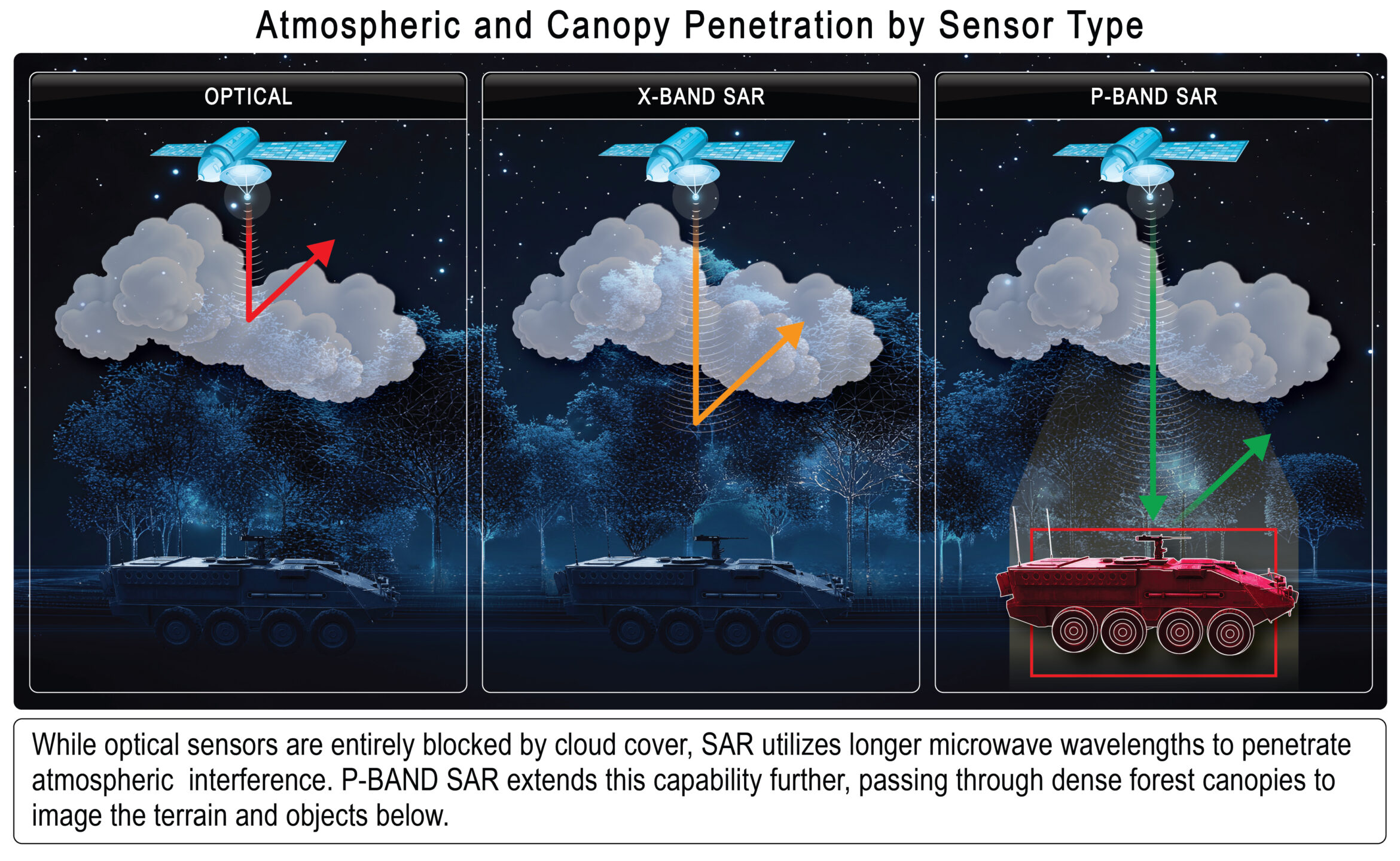
Synthetic Aperture Radar (SAR) is an active, all-weather, day-and-night remote-sensing technology that utilizes coherent electromagnetic microwave pulses to generate high-resolution, two- and three-dimensional images of the Earth’s surface. Because it functions independently of solar illumination and atmospheric obscurants, SAR is the non-negotiable backbone of modern geospatial security and defense intelligence.
Understanding the transformative power of SAR requires an examination of its underlying physics. Traditional optical sensors are passive; they rely on the chaotic illumination of sunlight reflecting off the Earth’s surface. If that sunlight is blocked by cloud cover, atmospheric haze, or darkness, the optical sensor is rendered blind. In stark contrast, SAR is an active sensor. It generates and transmits its own coherent electromagnetic energy—specifically focused microwave signals—toward the target area. The system then meticulously records the reflected echoes (backscatter) as they bounce off structures, vegetation, and the terrain.
The primary physical limitation of any radar system is spatial resolution, which is directly proportional to the physical length of the radar antenna. To achieve high-resolution imagery from orbit or high altitudes, a conventional radar system would require an antenna spanning hundreds of meters—a size that is aerodynamically and economically impossible for aircraft or satellites to carry.
SAR circumvents this physical impossibility through complex signal processing and the principle of “aperture synthesis.” As the platform (an aircraft, drone, or satellite) moves along its flight path, it transmits thousands of discrete radar pulses in rapid succession. The radar’s receiver collects the phase and amplitude of the returning echoes. By leveraging the forward motion of the platform, the system computationally combines these successive echoes, effectively simulating—or synthesizing—an antenna aperture that is immensely longer than the physical hardware. This synthetic aperture allows relatively small, rapidly deployable platforms to deliver sub-meter, high-definition imagery.
The Physics of SAR Resolution and Doppler Tracking
The data structure of raw SAR imagery differs significantly from traditional optical photographs. Optical data typically features spatial resolutions that are perfectly square (e.g., a pixel representing 10×10 meters on the ground). However, raw radar data possesses spatial resolutions in the slant range (the line-of-sight distance from the radar to the target) that are inherently non-square (e.g., 5×8 meters). For this data to be utilized by intelligence analysts or automated tracking systems, the image must undergo complex geometric correction, projecting the slant range data onto the ground range to form a mathematically accurate square pixel matrix.
Furthermore, SAR technology leverages the Doppler effect to track moving targets—a critical capability for modern military operations. As the SAR platform moves relative to the target on the ground, the frequency of the returning radar echo shifts. This shift, known as the Doppler frequency (f_d), increases with the base frequency (f) and is calculated using the formula: f_d = f(1 + (u/c) \cos \theta), where u represents the relative velocity of motion, c is the speed of light, and \theta is the angle between the direction of velocity and the direct line of sight to the target.
By analyzing these precise frequency shifts, modern SAR systems incorporate Ground Moving Target Indicator (GMTI) functionality. GMTI allows analysts to filter out stationary background clutter and isolate moving vehicles, maritime vessels, or troop formations. When operating at extremely high frequencies, such as 94 GHz, the Doppler frequency shift is ten times larger than at lower frequencies, allowing for the detection of exceedingly slow or subtle movements on the battlefield.
How Do Specific Radar Wavelengths Determine SAR Penetration Capabilities?
The operational capabilities of a SAR sensor are dictated primarily by the specific microwave frequency band—and corresponding wavelength—it employs, which determines its ability to penetrate atmospheric interference, dense vegetation, and subterranean barriers. Spatial resolution and penetration depth share an inverse relationship in radar mechanics: longer wavelengths provide greater penetration of the Earth’s topography, while shorter wavelengths yield higher-resolution surface details.
By selecting specific wavelengths, defense and commercial operators can tailor their intelligence-gathering efforts to the specific environmental challenges of the target theater.
SAR Frequency Bands and Strategic Applications
The electromagnetic spectrum utilized by SAR is segmented into distinct bands, each offering unique tactical advantages:
| Frequency Band | Wavelength Range | Penetration Capability and Primary Applications |
|---|---|---|
| X-Band | 2.4 cm - 3.8 cm | Minimal Penetration. Provides extreme high-resolution imagery for urban mapping, infrastructure analysis, and target identification. It cannot penetrate deep into vegetation or forest canopies. This band is utilized heavily by commercial constellations like ICEYE for precise 3 cm measurements. |
| C-Band | 3.8 cm - 7.5 cm | Moderate Penetration. Widely used for global environmental monitoring, maritime surveillance, tracking ocean wave spectra, and agricultural crop forecasting. Offers slight canopy penetration. |
| S-Band | 7.5 cm - 15 cm | Medium Penetration. Balances resolution with the ability to penetrate light weather and sparse vegetation. Often utilized in avionics and specialized maritime search operations. |
| L-Band | 15 cm - 30 cm | High Penetration. Highly effective for Earth observation, detecting surface deformation, and significant canopy penetration. Due to escalating climate risks, L-band analysis has become essential for cloud-penetrating disaster monitoring. |
| P-Band | 30 cm - 110 cm | Maximum Penetration. Capable of penetrating deep into dense forests, thick vegetation, soil, and glacial ice. P-band is uniquely suited for Foliage Penetration (FOPEN) missions, uncovering hidden subterranean tunnels, bunkers, and concealed encampments. |
In contested environments, particularly in heavily forested regions like Central and South America, Foliage Penetration (FOPEN) is a mission-critical capability. While high-frequency X-band radar provides stunningly detailed images of the top of a jungle canopy, it is effectively blind to what lies beneath. Lower-frequency systems, such as P-band and L-band, allow the microwave energy to pass through the leaves and branches, reflecting off the solid structures, vehicles, or supply routes hidden on the forest floor. This wavelength mastery is what makes SAR an indispensable asset in modern counter-insurgency and anti-narcotics operations.
Why Is Synthetic Aperture Radar Technologically Superior to Optical and LiDAR Systems?
Because SAR generates its own coherent electromagnetic illumination and operates at wavelengths that pass through clouds, thick smoke, and darkness, it provides a persistent, uninterrupted intelligence feed that optical cameras and Light Detection and Ranging (LiDAR) systems simply cannot match. In intelligence, surveillance, and reconnaissance (ISR) operations, the inability to observe an adversary due to weather is a critical vulnerability. SAR eliminates this vulnerability entirely.
While optical sensors rely on a light beam and a clear line of sight, they are frequently disrupted. If an optical sensor attempts to image an area covered by a thunderstorm or thick smoke from a battlefield, the visible light is blocked, and the sensor reads the target area as obscured.
Similarly, LiDAR—which is exceptional for creating high-precision 3D topographical maps—relies on near-infrared and visible light lasers. Consequently, LiDAR suffers from significant performance degradation in heavy rain, fog, and cloud cover.
The technological superiority of SAR rests on three distinct operational pillars that differentiate it from other imaging technologies:
- Persistent Monitoring and Coherent Change Detection (CCD): Because SAR performance is unaffected by the time of day or local weather patterns, platforms can repeatedly image the exact same geographic coordinate over continuous intervals. This persistent monitoring enables Coherent Change Detection (CCD). By comparing the phase differences in SAR images taken days or weeks apart, analysts can detect microscopic environmental or structural changes—such as fresh tire tracks in dirt, recently buried improvised explosive devices (IEDs), or minor structural shifts in civil infrastructure—that are entirely invisible to the naked eye.
- Multi-Polarization Data Extraction: Advanced SAR systems transmit and receive signals in multiple polarizations (e.g., horizontal transmission/horizontal reception, or horizontal transmission/vertical reception). Different materials and geometric shapes reflect these polarized waves differently. By collecting multi-polarized images simultaneously, intelligence analysts can deduce a target’s material composition, surface roughness, and exact orientation, adding a vital layer of depth to target identification.
- High-Resolution from Compact Platforms: By utilizing the synthetic aperture technique, SAR delivers extreme high-resolution imagery using relatively short, lightweight physical antennas. This is profoundly advantageous for modern defense strategy, as it allows advanced radar suites to be integrated onto rapid, high-altitude business jets, mid-sized drones, and small commercial satellites, drastically reducing the logistical footprint required for persistent ISR.
How Is Synthetic Aperture Radar Deployed in Modern Military Operations?
In modern defense strategies, SAR serves as the paramount sensor for multidomain awareness, enabling commanders to track enemy movements, execute precision target acquisition, and conduct damage assessments in highly contested and visually obscured environments. The integration of SAR into military operations provides an asymmetric advantage, allowing allied forces to observe without being observed, and to strike with unparalleled precision.
The strategic deployment of SAR spans several critical military applications:
- Continuous Surveillance and Reconnaissance: SAR provides an unblinking eye over vast land and maritime domains. Its all-weather, all-hours functionality makes it the ideal tool for establishing “patterns of life” and tracking adversary troop deployments. In naval operations, SAR can identify non-compliant vessels or hostile ships across massive ocean expanses, regardless of sea state or weather.
- Precision Target Acquisition: By leveraging Ground Moving Target Indicator (GMTI) data derived from Doppler shifts, SAR systems can isolate and track mobile threats, such as enemy armored columns or mobile missile launchers. This precise geolocational data is fed directly into the kill chain to guide airstrikes, artillery, or long-range precision fires.
- Suppression of Enemy Air Defenses (SEAD): SEAD missions are among the most dangerous in modern warfare. SAR provides a crucial advantage by helping to identify and precisely locate hostile surface-to-air missile (SAM) installations and early-warning radar nodes. Because SAR can penetrate camouflage netting and light foliage, it exposes air defense assets that are specifically hidden from optical satellites.
- Post-Strike Damage Assessment: Following an kinetic engagement, commanders require immediate verification of target destruction. SAR is deployed to assess the structural damage caused by military operations. Because it does not require daylight, damage assessments can be conducted immediately after nighttime strikes, accelerating the decision-making cycle for subsequent operations.
- Strategic Mapping and Logistics: SAR’s ability to create highly detailed, topographical maps of the Earth’s surface is vital for operational planning. These maps inform ground troop movements, identify viable landing zones, and monitor environmental changes that could impact supply lines.
The historical pedigree of SAR in combat is extensive. During the Gulf War, SAR platforms were instrumental in tracking Iraqi troop movements and identifying targets through intense smoke generated by burning oil wells. During the Afghanistan War, the technology was heavily relied upon to map treacherous, mountainous terrain and identify insurgent positions hidden in deep ravines. More recently, during the Syrian Civil War, SAR was deployed to continuously monitor the mass movement of refugees and assess widespread damage to urban infrastructure. Today, SAR is transitioning from an operational support tool to the primary driver of the automated intelligence kill chain.
What Is MAG Aerospace’s Strategic Role in Next-Generation C5ISR?
MAG Aerospace operates as a leading independent provider of turnkey, full-spectrum C5ISR services, seamlessly integrating premier Synthetic Aperture Radar technologies into contractor-owned, contractor-operated (COCO) aerial platforms to deliver actionable intelligence to the U.S. government and allied nations. Rather than simply manufacturing hardware, MAG Aerospace takes full operational responsibility for the intelligence lifecycle—from data collection and processing to exploitation and near real-time dissemination.
The corporate scale and capability of MAG Aerospace underline its dominance in the airborne ISR market. MAG Aerospace’s operational philosophy is built on Multi-Intelligence (Multi-INT) data collection. By layering SAR data alongside electro-optical/infra-red (EO/IR) full-motion video (FMV), Foliage-Penetrating (FOPEN) LiDAR, hyperspectral imagery (HSI), and signals intelligence (SIGINT), MAG creates a dense, impenetrable web of situational awareness for combatant commanders.
Elite Past Performance in SOUTHCOM and Anti-Narcotics Operations
The efficacy of MAG Aerospace’s turnkey ISR model is definitively proven through its sustained deployments in the U.S. Southern Command (SOUTHCOM) area of responsibility. Tasked with countering sophisticated transnational narcotrafficking networks in Latin America, MAG deployed multiple COCO ISR platforms equipped with premier SAR arrays and class-leading high-resolution HF/VHF/UHF geolocation systems.
The logistical burden of these operations is immense. MAG assumes total responsibility for aircraft maintenance, logistics, pilot deployment, payload operation, networking specialists, and intelligence analysts. Despite the austere operating conditions, the statistical outcomes of these missions are remarkable:
- Total Missions Flown: Over 2,700 targeted missions.
- Intelligence Targets Collected: Over 7,000 specific targets identified and tracked.
- Data Production: Over 150,000 full-motion video and still-frame images produced for interdiction teams.
- Operational Readiness: Sustained an aircraft availability rate exceeding 95%.
Central and South America Operational Support
In a parallel effort supporting federal operations in Central and South America, MAG operated a highly specialized multi-sensor aircraft outfitted with FOPEN LiDAR and SAR systems. The mission required near real-time intelligence collection while the aircraft was in flight, combined with post-mission data exploitation. Over the course of this contract, MAG flew over 400 missions, satisfying more than 1,200 LiDAR targets and 1,900 SAR targets. The company’s technical proficiency resulted in an extraordinary SAR collection success rate of over 97%, guaranteeing that federal agencies received the precise intelligence required for strategic action.
How Are Airborne ISR Platforms Evolving to Meet 2026 Defense Requirements?
To counter emerging near-peer threats and operate effectively in contested environments, the U.S. Army is completely overhauling its intelligence fleet, retiring legacy turboprop aircraft in favor of highly modified, large-cabin business jets capable of rapid deployment, extreme high-altitude operation, and deep-sensing ISR. The era of slow, low-flying surveillance planes is concluding, replaced by sophisticated jet platforms that offer massive increases in range, speed, and sensor payload capacity.
For years, the U.S. Army relied on turboprop platforms like the RC-12 Guardrail to conduct electronic warfare and ISR missions. However, these aircraft lack the speed and altitude required for modern great power competition. In response, the Army initiated the High Accuracy Detection and Exploitation System (HADES) program, a $1 billion effort to deliver next-generation spy planes by the end of the decade. To bridge the gap before HADES becomes fully operational, the Army deployed immediate solutions through the ATHENA-R (Radar) and ATHENA-S (Signals Intelligence) programs.
The ATHENA-R Program and the Bombardier Global 6500
In late 2023, the U.S. Army awarded a prime contract to a consortium led by MAG Aerospace and L3Harris Technologies to deliver two fully missionized ATHENA-R aircraft. Built upon the airframe of the Bombardier Global 6500 business jet, the ATHENA-R represents a quantum leap in tactical intelligence capability.
The transition to the Global 6500 airframe provides over 18 hours of flight endurance, class-leading maintenance intervals, and ample cabin space for complex mission workstations. More importantly, operating at business-jet altitudes affords the aircraft significantly greater survivability and an exponentially wider targeting line-of-sight—essential factors for achieving the Army’s long-range precision fires modernization priorities.
The ATHENA-R is equipped with advanced Synthetic Aperture Radar systems designed to penetrate deep into adversary territory while the aircraft remains safely within friendly or international airspace. These radars seamlessly track moving targets on the ground via GMTI, while electronic intelligence systems provide simultaneous detection of air-defense nodes.
The operational integration of these platforms has been highly aggressive and highly successful. As of early 2026, the MAG Aerospace and L3Harris ATHENA-R platforms deployed in the U.S. Indo-Pacific Command (INDOPACOM) are averaging an astounding 400+ flight hours per month, executing critical, real-world ISR missions. Furthermore, in February 2025, the Army deployed the ATHENA-R platform for a rigorous four-month operational assessment, fine-tuning the platform while simultaneously supporting U.S. commitments to the INDOPACOM AOR.
The Transition to HADES
The lessons learned and operational data gathered by the ATHENA platforms are feeding directly into the development of the final HADES program. The HADES sensor package will feature the Advanced Synthetic Aperture Radar System-2B (ASARS-2B), an active electronically scanned array (AESA) radar. Originally developed to upgrade the U-2 Dragon Lady spy plane, the ASARS-2B produces highly detailed SAR ground maps and sophisticated GMTI tracking data, allowing analysts to establish deep “patterns of life” regarding adversary movements.
Demonstrating the urgency of this modernization, defense contractors are investing heavily ahead of government schedules. In late 2025, Sierra Nevada Corporation (SNC), the lead systems integrator for the HADES program, privately purchased a Bombardier Global 6500 to serve as the first non-prototype aircraft, aggressively pulling development schedules to the left and mitigating integration risks. Operational demonstration prototypes for HADES are anticipated in 2026, with the first fleet deliveries expected by 2030.
What Are the Top Defense Technology Trends and Modernization Priorities for 2026?
The defense technology landscape in 2026 is defined by a massive surge in domestic innovation, fueled by historic budget allocations and an aggressive pivot toward artificial intelligence, hypersonic weapons, and resilient supply chain security. As the U.S. Department of Defense (DoD) transitions from reactive counter-insurgency postures to persistent engagement in contested digital and physical environments, technology procurement has shifted dramatically.
The Fiscal Year 2026 National Defense Authorization Act (NDAA) secured a staggering $900.6 billion for national defense. These funds are heavily prioritized toward revitalizing the defense industrial base and deploying new multidomain technologies. Concurrently, European nations are fundamentally reassessing their strategic postures, with many aiming to more than double their defense spending to reach 5% of their GDP annually by 2035.
The top technological priorities dominating defense innovation in 2026 include:
- Pervasive Artificial Intelligence: AI has moved entirely from the experimental phase to become the foundational element of U.S. defense doctrine. In late 2025, the DoD rolled out GenAI.mil, a bespoke generative AI platform utilizing Google Cloud’s Gemini models, making advanced AI tools available to military personnel globally. This AI powers predictive maintenance, autonomous systems, and incredibly rapid decision-making cycles.
- Hypersonics and Missile Defense: Driven by the need for extreme speed, maneuverability, and survivability, hypersonic weapons and the radar systems required to detect them remain central to U.S. and allied modernization efforts.
- Cyberwarfare and Electromagnetic Convergence: Operations are advancing toward highly integrated offensive and defensive cyber strategies. Defense networks are leveraging automation and advanced analytics to disrupt adversary networks while simultaneously hardening friendly C5ISR links against sophisticated hacking attempts.
- Rapid Prototyping and OTA Procurement: The traditional, decades-long defense procurement cycle is obsolete. Innovation in 2026 relies heavily on utilizing the Other Transaction Authority (OTA), a flexible procurement mechanism that allows the government to bypass bureaucratic red tape and rapidly prototype and field technologies with commercial partners.
How Is Artificial Intelligence Revolutionizing SAR and Edge Computing?
Artificial Intelligence—specifically the transition from Generative AI to Agentic AI—is transforming Synthetic Aperture Radar from a passive data-collection tool into an autonomous, predictive intelligence network that operates directly at the tactical edge. The volume of high-resolution data produced by modern Multi-INT aircraft and satellite constellations is vast; transmitting this raw data back to centralized ground stations creates unacceptable latency and vulnerabilities in bandwidth-constrained, contested environments.
To solve the data bottleneck, the defense industry is aggressively deploying edge computing. By embedding ruggedized, high-performance computing hardware directly onto the ISR aircraft or satellite, AI models can analyze SAR telemetry and sensor feeds locally, in real-time. Instead of sending gigabytes of raw radar imagery, the edge system autonomously identifies the target, verifies the threat, and transmits only a concise, actionable alert to the combatant commander.
Generative AI vs. Agentic AI in Defense
The evolution of military AI technology is currently defined by the complementary roles of Generative and Agentic AI :
- Generative AI focuses on rapid creation. It is used to generate code, run simulations, design alternative models, and synthesize complex intelligence reports.
- Agentic AI represents the next leap forward. It possesses the capability to autonomously plan, make decisions, and take actions across workflows without human prompting. When paired with SAR platforms, Agentic AI can independently cross-cue sensors (e.g., instructing an EO/IR camera to focus on an anomaly detected by the SAR), optimize flight paths, and manage iterative target tracking.
What Are the Financial Projections for the Global SAR and Satellite Data Markets?
Propelled by escalating geopolitical tensions, the necessity for all-weather Earth observation, and the commercialization of low Earth orbit (LEO), the global Synthetic Aperture Radar and Satellite Data Services markets are experiencing explosive, sustained financial growth. Government mandates, such as the European Union’s early 2026 “Radar-First” directive—which prioritized SAR data for all member-state climate and security compliance—have transitioned SAR from a discretionary capability to a regulatory requirement.
Global Synthetic Aperture Radar (SAR) Market Forecast
Market analysts project a highly aggressive growth trajectory for the SAR sector through the next decade. While varying reports offer slightly different baseline valuations, the consensus indicates massive expansion:
- In 2024, the SAR market was valued at approximately $4.65 billion.
- By 2026, the market value is estimated to reach $6.22 billion.
- Forecasts project the market will surge to $9.96 billion by 2030, and nearly $11.94 billion by 2032.
- This represents a sustained Compound Annual Growth Rate (CAGR) of 12.5%.
This growth is distinctly fueled by a 12% increase in SAR defense spending recorded in 2026, driven by modernization programs in the U.S. and NATO. Regionally, North America remains the dominant force, holding a 34.3% revenue share driven by vast investments in space and defense. However, the Asia-Pacific region is the fastest-growing market, spurred by rapid urbanization, border security concerns, and massive investments in China and India.
Satellite Data Services and Commercial Imagery
Beyond the physical hardware, the market for the data produced by these satellites is expanding even faster. The global satellite data services market, valued at $12.95 billion in 2025, is projected to hit $45 billion by 2035, driven by an extraordinary CAGR of 19.55%.
Concurrently, the specific commercial satellite imagery segment is projected to grow from $7.01 billion in 2026 to $15.29 billion by 2032 (a 13.88% CAGR). This commercialization is aided by a 4% decrease in per-square-kilometer imaging costs, making SAR data economically viable for a broader range of civilian and corporate applications.
How Are Commercial Satellite Constellations Democratizing SAR Access?
The historical paradigm—where SAR technology was exclusively controlled by massive, well-funded government intelligence agencies—has been shattered by the rapid deployment of commercial micro-satellite constellations. Advancements in satellite miniaturization, dramatic reductions in launch costs, and commercial breakthroughs in radar processing algorithms have made space-based SAR universally accessible.
Companies like ICEYE have revolutionized the industry by launching constellations of smaller, lighter SAR satellites. Because these satellites are relatively inexpensive to build and launch, companies can deploy dozens of them, creating a massive web of coverage that drastically reduces “revisit times” (the time it takes for a satellite to pass over the exact same location again).
In March 2025, ICEYE launched its Generation 4 (“Gen4”) satellites aboard a SpaceX Transporter-13 rideshare mission. These Gen4 satellites represent a massive technological leap: they doubled both the physical size of the SAR antenna and the radiated SAR power. This innovation expanded the imaging swath width from 150 km to 400 km, while simultaneously delivering 30% greater information density at a 25 cm resolution.
The strategic implications of these commercial constellations are profound. In mid-2025, the Royal Netherlands Air Force (RNLAF) selected ICEYE to provide its first sovereign, space-based military ISR capabilities. Within just four months of contract signing, ICEYE delivered a suite of solutions, including access to a 48-satellite constellation, an AI-driven intelligence hub, and dedicated 25 cm resolution imaging. This demonstrates how allied nations can rapidly acquire world-class space defense capabilities without investing decades into domestic space program development.
This proliferation is heavily supported by dedicated small-satellite launch providers. Rocket Lab’s Electron rocket, having completed over 50 missions, leads the commercial sector in providing highly precise, dedicated orbital placement for micro-satellites, allowing SAR operators to customize their orbital inclinations for maximum surveillance efficiency.
What Are the Latest Technological Advancements in SAR Architectures?
As we move deeper into 2026, SAR engineering is shifting away from monolithic, ground-commanded platforms toward highly autonomous, distributed, and AI-optimized radar architectures. An analysis of recent intellectual property filings reveals three critical vectors defining the future of SAR technology:
- On-Orbit Autonomous SAR Mission Planning: Traditionally, satellites required extensive ground-in-the-loop communication to plan imaging tasks. Emerging patents, particularly from the Qilu Space-Air Information Research Institute, demonstrate systems where mission intelligence is pushed directly onto the satellite. This allows the satellite to autonomously prioritize and schedule its own imaging tasks based on real-time events, drastically reducing latency for time-critical surveillance and disaster response.
- Distributed and Bistatic Radar Architectures: The future of space-based SAR relies on decoupling the transmitter and receiver. In a bistatic configuration, one massive platform (or a geostationary satellite) acts solely as the microwave transmitter, bathing a target area in electromagnetic energy. Simultaneously, a swarm of independent, highly mobile receivers (such as small drones or LEO micro-satellites) collect the scattered echoes. Because the receivers do not emit a signal, they are virtually undetectable by enemy Electronic Warfare (EW) systems, ensuring survivability in highly contested environments.
- Neural Network and Sparse Reconstruction: AI is not just analyzing the final image; it is being used to build it. Neural networks are increasingly utilized to assist in the complex image formation process, allowing high-resolution images to be computationally reconstructed from fewer radar pulses, conserving massive amounts of onboard energy and processing power.
To learn more about our SAR and data collection capabilities as well as our entire C5ISR program, contact MAG today!
Frequently Asked Questions (FAQ)
1. What is Synthetic Aperture Radar (SAR) and how does it differ from optical imaging?
Synthetic aperture radar (SAR) is an active remote-sensing technology that transmits its own microwave pulses to the Earth’s surface and records the returning echoes to create high-resolution imagery. Unlike optical imaging, which relies on sunlight and is blocked by clouds or darkness, SAR’s coherent illumination and longer wavelengths allow it to see through weather, smoke, and total darkness. By utilizing the forward motion of the aircraft or satellite to computationally simulate a massive antenna, SAR achieves extreme precision from compact, mobile platforms.
2. What does C5ISR stand for and why is it important in defense operations?
C5ISR stands for Command, Control, Computers, Communications, Cyber, Intelligence, Surveillance, and Reconnaissance. It represents the comprehensive, interconnected network of sensors, data-processing hardware, secure communication architectures, and analytical software used by modern militaries. C5ISR systems provide commanders with real-time situational awareness, allowing them to track threats, direct forces, and execute multidomain operations securely. Turnkey C5ISR providers, such as MAG Aerospace, manage the entire lifecycle of this data, from aerial collection to ground-based exploitation.
3. Why is the U.S. Army transitioning to business jet ISR platforms like ATHENA-R?
The U.S. Army is transitioning from legacy turboprop aircraft to high-altitude, large-cabin business jets like the Bombardier Global 6500 to significantly increase operational survivability, speed, and deep-sensing capabilities. Jets like the ATHENA-R provide much greater payload capacities for heavy, advanced SAR and SIGINT sensors. Furthermore, their ability to fly at commercial altitudes extends their targeting line-of-sight deep into enemy territory while remaining safely outside the engagement range of adversary surface-to-air missile threats.
4. How is artificial intelligence transforming airborne ISR and SAR data?
Artificial intelligence, specifically the shift toward agentic AI, is revolutionizing airborne ISR by automating data processing, exploitation, and dissemination (PED) directly at the tactical edge. Instead of transmitting terabytes of raw SAR data back to a vulnerable ground station, onboard AI algorithms autonomously detect anomalies, classify specific targets, and instantly transmit concise, high-value alerts to combatant commanders. This edge computing approach drastically reduces latency, conserves bandwidth, and accelerates the kill chain in contested environments.
5. What is Foliage Penetration (FOPEN) and why is it critical?
Foliage Penetration (FOPEN) is a specialized application of SAR that utilizes lower-frequency microwave wavelengths, primarily the P-band and L-band, to see through dense vegetation. While optical cameras and high-frequency radars bounce off the top of a forest canopy, FOPEN signals pass through the leaves and branches to reflect off solid objects on the ground. This capability is critical for counter-insurgency and anti-narcotics operations, as it reveals hidden supply routes, subterranean tunnel entrances, and concealed encampments that are otherwise invisible.
Originally published June 2023
Updated April 2026