The Common Operating Picture (COP) is a continuously updated, centralized tactical and strategic display of information that allows personnel in command and control roles to make effective decisions based on an integrated understanding of evolving situations. In 2026, the transition from fragmented data silos to unified situational awareness platforms represents a foundational shift in enterprise, public safety, and defense management.
Impact of deploying a modern common operating picture:
- Response Time Optimization: Consolidating fragmented data intake points into a single, unified common operating picture has been proven to reduce critical response times by 34%, while simultaneously driving Service Level Agreement (SLA) adherence from 60% up to a staggering 94% within a 90-day implementation window.
- Market Capitalization and Growth: The global Command, Control, Communication, Computers, Cyber, Intelligence, Surveillance and Reconnaissance (C5ISR) market, which serves as the architectural foundation for defense-oriented common operating pictures, reached $141.4 billion in 2025 and is projected to scale to $194.5 billion by 2034, reflecting a compound annual growth rate (CAGR) of 3.42%.
- Data Integrity and Commercial Efficiency: Commercial utilities leveraging a Geographic Information System (GIS) based common operating picture have recorded an 80% improvement in network data integrity and a 25% enhancement in business decision-making speed by eliminating paper-based lags and siloed computer-aided design (CAD) files.
- Supply Chain Visibility Gaps: Despite advanced digitization efforts across global trade, only 6% of global logistics enterprises report having full, end-to-end supply chain visibility, highlighting a massive operational vulnerability that modern common operating pictures are designed to solve.
- Budget Resilience and Consolidation: Demonstrating the critical nature of these systems in the artificial intelligence era, 96% of enterprise organizations are maintaining or increasing their observability and situational awareness budgets in 2026, with 84% actively pursuing tool consolidation to build unified, rather than fragmented, operating pictures.
1. Introduction: The Evolution and Ontology of the Common Operating Picture
The concept of the common operating picture has transcended its traditional military origins to become the central nervous system of any high-stakes operational environment. At its core, a common operating picture is a tactical and strategic display of information that allows leadership to make effective, high-velocity decisions based on an up-to-date, holistic understanding of the situation at hand. Created by collecting data from multiple disparate sources and merging them into one cohesive display, the common operating picture provides users with immediate, real-time access to facts regarding current operational status, evolving environmental threats, resource availability, and the precise geospatial locations of critical assets.
In 2026, the global operational landscape is defined by vast streams of unstructured data, rapidly shifting geopolitical supply chains, and the deep integration of artificial intelligence into daily workflows. Organizations that operate without a common operating picture suffer from a severe “hidden tax” of lost visibility, wasted capacity, and broken accountability. This hidden tax manifests in the form of delayed emergency responses, disjointed supply chain logistics, and compromised battlefield awareness. By sharing a unified knowledge base across all involved organizations, departments, or jurisdictions, collaborative planning can be executed with unprecedented efficiency, ensuring consistent situational awareness for all parties engaged in an incident at any given time.
1.1 The Crucial Distinction: Common Operating Picture vs. Common Tactical Picture
A frequent point of confusion within command and control (C2) environments is the semantic and architectural distinction between a Common Operating Picture (COP) and a Common Tactical Picture (CTP). Understanding this divergence is critical for proper system architecture, procurement, and deployment.
The primary difference lies in the lifespan of the ingested data and the overarching scope of the perspective. Common Tactical Pictures are typically generated from raw, ground-level sensor data, focusing heavily on short-term time spans and immediate, localized spatial relationships. A Common Tactical Picture might display the active radar track of an incoming munition, the exact GPS coordinates of a first responder entering a burning structure, or the immediate telemetry of a commercial drone. The data feeding a Common Tactical Picture is highly perishable; it is vital for the individual operator in the moment but loses its relevance quickly as the tactical situation evolves.
Conversely, a common operating picture provides a much broader strategic view, focusing on the synthesis of data with long life spans and wide-ranging operational implications. For example, a defense-oriented common operating picture integrates the immediate aerial view of the battlefield alongside enduring information regarding echelon supply levels, personnel readiness metrics, geopolitical weather patterns, and long-term logistical availability. It is the synthesis of the tactical and the strategic, allowing executives and commanders not just to react to an immediate, localized threat, but to orchestrate multi-domain operations with a clear, uninterrupted understanding of their total sustainment capacity and strategic positioning.
1.2 The Philosophical Shift to Situational Intelligence
The modern implementation of a common operating picture represents a philosophical shift from mere data collection to “situational intelligence.” Historically, information during a crisis or complex operation oscillated between an overwhelming, unmanageable flood of raw data and an insufficient, localized trickle of unverified facts. Organizational structures, rigorous training protocols, and legacy technologies all struggled to generate accurate, complete, and current situational awareness.
The common operating picture solves this by contextualizing information. It ensures that the data collected is well-analyzed and utilized wherever it is meaningful, diverting resources away from less effective activities and directing them toward actions that make a tangible difference. This shift from passive data monitoring to active situational intelligence is the defining characteristic of elite organizations in 2026, enabling a proactive posture that anticipates friction points rather than merely responding to system failures.
1.3 Who Uses a COP?
COPs are widely employed in the military, providing commanders with an understanding of battlefield conditions to make informed decisions faster. Although COPs have traditionally been used in combat operations, they can also help coordinate complex logistics and personnel management tasks such as tracking equipment supply and managing resources.
COPs are essential not just to the military but to other organizations as well. They help reduce confusion and ensure that all stakeholders have access to accurate information in real-time. This can be especially useful in complex situations involving multiple organizations, such as humanitarian relief efforts or large-scale infrastructure projects.
1.4 Benefits of a COP
The benefits of having a Common Operating Picture (COP) are numerous. By allowing multiple sources of information to be collected, merged, and then shared with all involved organizations, collaborative planning can be done more effectively. Having the COP also enhances situational awareness for incident management teams and other personnel by providing a unified view of the situation.
Also, the COP reduces the time it takes to communicate any changes in resource deployment or location, thus increasing response times during an emergency. Additionally, it eliminates confusion when multiple agencies are involved in responding to an incident, as everyone is now looking at the same up-to-date information instead of having different versions of the same story. Furthermore, it allows field teams to make better decisions based on accurate data plus visibility into where assets are located, which is very beneficial in a tactical setting.
1.5 Components of a COP
Data from multiple sources can frequently be incorporated into COPs based on the user’s requirements. These sources can include government networks and databases, GIS systems, geospatial images and maps, communication tools, satellite imagery, aerial surveillance data, and weather information. COPs can also be generated from manual inputs such as reports or observations made by field personnel.
A COP may also use real-time data streams for immediate situational awareness. For example, streaming video from drones or other airborne surveillance platforms can provide an up-to-date view of the operation or incident in progress. Alternatively, data feeds from cellphone towers or other network infrastructure can be used to track the movement of units and personnel in the field. Combining real-time and historical data into one unified picture gives operational teams a powerful tool for understanding their environment.
1.6 Applications of a COP
The Common Operating Picture (COP) is often used in various scenarios, from handling large-scale incidents to small-scale operations. In emergency management or incident response, the shared COP allows personnel to monitor the situation, identify potential risks, and formulate plans faster and more effectively. The COP can also assist with resource tracking and deployment by confirming actual versus projected numbers and locations.
In military operations, the COP provides an overall view of an operation’s progress, helping commanders make informed decisions about their next steps. It is also often utilized for intelligence-gathering missions to uncover trends or patterns that may indicate a threat.
Additionally, the COP can be used in other operational areas, such as logistics or transportation management. By allowing users to track their resources visually, they can better manage their fleet movements or optimize their supply chain based on clear visuals of potential issues or bottlenecks. Finally, the COP allows users across different departments or business units to collaborate more effectively and efficiently on projects.
2. Market Dynamics and the Financial Imperative of Situational Awareness
The technological demands of modern situational awareness have created a surging, highly lucrative market for Command, Control, Communication, Computers, Cyber, Intelligence, Surveillance and Reconnaissance (C5ISR) technologies and services. The global defense technology landscape is undergoing significant macroeconomic shifts, propelled by fast-moving innovations, geopolitical friction, and an exponentially increasing demand for autonomous computing power.
2.1 The Explosive Expansion of the C5ISR Market
The underlying architecture of the common operating picture relies heavily on the C5ISR sector. The global C5ISR market size reached an estimated USD 141.4 billion in 2025. Driven by rising geopolitical tensions, the urgent modernization of global defense forces, and increased corporate investments in situational awareness technologies to protect supply chains, the market is projected to reach USD 194.5 billion by 2034, exhibiting a compound annual growth rate (CAGR) of 3.42% during the 2026-2034 forecast period. Other rigorous industry analyses point to an even steeper growth curve, estimating a 4.2% CAGR from 2025 to 2033, fueled by a massive surge in demand for integrated, technology-enabled solutions that enhance real-time decision-making and mission-critical communication.
This massive capital investment is heavily concentrated in the adoption of unmanned systems. Unmanned Aerial Vehicles (UAVs), Unmanned Ground Vehicles (UGVs), and Unmanned Maritime Vehicles (UMVs) all act as primary, autonomous sensor nodes feeding continuous data back into the common operating picture. North America currently dominates the global market share, an economic reality attributed to the region’s significant military expenditures, advanced commercial logistics networks, and an overwhelming focus on network-centric warfare principles.
2.2 Demonstrating Financial Return on Investment (ROI)
For public sector agencies and commercial organizations seeking to justify the significant capital expenditure required to architect a common operating picture, the financial and operational Return on Investment (ROI) metrics are highly compelling. The value is generated not just in increased capability, but in profound cost avoidance and operational efficiency.
- Cost and Complexity Reduction: By marshaling disparate data feeds into a single framework, organizations avoid the massive, paralyzing expense of “rip-and-replace” legacy system overhauls. The common operating picture acts as an intelligent integration layer, extending the useful life of older underlying systems while drastically reducing the operational inefficiencies and cognitive load of operators switching between multiple independent screens.
- Direct Operational Efficiency: The Defense Contract Management Agency (DCMA), which manages over 300,000 active contracts valued at $5.9 trillion, reported an astounding ROI of 5.83 to 1 in fiscal year 2024. This exceptional performance in contract administration and oversight relies heavily on comprehensive data visibility, shared intelligence, and a unified operating picture to manage contractor payments averaging more than $1 billion each business day.
- Market Leadership Performance: Major commercial players in the common operating picture ecosystem demonstrate immense financial health.
Conversely, the financial cost of not having a common operating picture is equally stark. Global employee disengagement—often exacerbated by poor organizational tooling, fragmented communication, and a lack of clear operational visibility across distributed teams—cost the global economy an estimated $438 billion in lost productivity in 2024. Implementing a common operating picture provides the clarity, direction, and shared reality necessary to align massive teams and mitigate these crippling productivity losses, proving that situational awareness is fundamentally an economic imperative.
3. Architecting the Modern Common Operating Picture
To build operational trust and ensure data veracity in a decentralized environment, a common operating picture must be constructed on a resilient, open architecture capable of digesting multiple, highly complex data streams simultaneously. Modern artificial intelligence tools and advanced analytics engines pull specific text passages, telemetry, and geospatial inputs using retrieval-augmented generation (RAG) and structured data models. Therefore, the underlying architecture must be technically pristine.
3.1 Foundational Components and Ingestion Methods
The effectiveness of any common operating picture is entirely dependent on the quality, velocity, and seamless integration of its constituent data sources. Data from multiple streams are continuously incorporated based on exact user requirements and the specific demands of the operational environment.
The primary structural components include:
- Geographic Information Systems (GIS): GIS remains the visual and spatial anchor of the common operating picture. Geography is inherently integrative, weaving together disciplines such as climatology, economics, and urban planning into a coherent framework. Advanced spatial tessellation, such as the H3 hexagonal framework, allows for the precise plotting of trends, patterns, and hotspots, connecting billions of inputs to update maps globally. GIS integrates government databases, geospatial imagery, and foundational base maps into a digestible format.
- Real-Time Data Streams (IoT and Edge Sensors): The modern common operating picture consumes real-time telemetry from drones, airborne surveillance platforms, and ground-level Internet of Things (IoT) sensors. Streaming video from Unmanned Aerial Systems (UAS) and data feeds from network infrastructure—such as cellphone tower pings—are used to track the dynamic movement of units, vehicles, and personnel in the field.
- Historical and Predictive Analytics: Combining real-time sensor data with historical archives creates a powerful tool for profound environmental understanding. In 2026, this involves agentic AI reasoning engines that do not just display current data but predict future bottlenecks, equipment failures, or threat vectors based on deep historical patterns.
- Human Intelligence (HUMINT) and Manual Inputs: Despite sweeping technological advancements, observational reports from field personnel remain crucial to maintaining ground truth. Modern common operating pictures feature mobile-optimized interfaces that allow field teams to update the system dynamically, ensuring that the human perspective aligns perfectly with sensor readings.
3.2 Overcoming the “Five Front Doors” Problem
A persistent challenge in both commercial logistics and public safety is the severe fragmentation of information systems. As budgets and functional requirements change over time, organizations inevitably build up an array of isolated command and control systems. Interaction between these systems is typically non-existent, requiring cumbersome manual workflows to bridge the massive intelligence gaps.
This phenomenon, often referred to in the industry as the “five front doors” problem, creates a hidden tax on mission capacity. Emergency operations personnel are forced to leverage dozens of disconnected sources—weather data, school statuses, private company feeds, and public agency databases—creating time-consuming manual labor to build a makeshift common operating picture. Practitioners deal with stale data, dangerous information gaps, and friction between incompatible software environments while trying to synchronize multiple organizations into a coordinated response.
By unifying these live data inputs through an open architecture platform, organizations reduce manual work, eliminate information silos, and establish a single intake point for all request types. Consolidating to a single intake point and a unified common operating picture has proven to reduce response time by 34%, eliminating the wasted capacity and broken accountability inherent in fragmented systems.

4. Military and Defense Operations: The Pursuit of Decision Dominance
In military operations, the common operating picture provides an indispensable, overarching view of an operation’s progress, helping commanders make informed decisions about their next steps with unprecedented speed. The strategic focus for the United States Department of Defense and allied forces in 2026 has shifted from mere situational awareness to achieving “Decision Dominance”—the ability to sense, make sense, and act significantly faster than an adversary can orient themselves.
4.1 Joint All-Domain Command and Control (JADC2)
The United States military has heavily prioritized Joint All-Domain Command and Control (JADC2), a revolutionary warfighting concept entirely dependent on a robust, frictionless common operating picture. The fundamental goal is to connect sensors and shooters from all military services—Air Force, Army, Marine Corps, Navy, and Space Force—into a single, unified, cloud-like network.
During landmark initiatives like Project Convergence, the military demonstrated how integrating data from multiple sensors, including remotely piloted vehicles, directly into the common operational picture allowed commanders to rapidly execute joint “sensor-to-shooter” use cases across different branches of service. Establishing a Joint Board of Directors comprising 19 three-star generals and admirals from all five services, the initiative proved that having a common operating picture across the services is mandatory to inform future combat concepts.
Programs such as the Air Space Total Awareness for Rapid Tactical Execution (ASTARTE) explicitly seek advanced low-cost sensors, artificial intelligence software algorithms, and virtual testing environments to build a strong common operating picture capable of operating in degraded, denied, intermittent, or limited (DDIL) environments. ASTARTE aims to complement JADC2 by integrating command and control in the most difficult airspace, often cluttered with friendly and enemy aerial forces, intense signal jamming, and other communication-denial systems.
4.2 Army Readiness and the Logistics Common Operating Picture
Beyond the immediate kinetic fight, the common operating picture is heavily utilized for military sustainment and logistics. The Army Readiness-Common Operating Picture (AR-COP) provides commanders with a visual, interactive dashboard displaying supply and maintenance statuses, enabling them to anticipate critical sustainment shortfalls before they result in a catastrophic loss of combat power.
By pulling transactional data directly from the Global Combat Support System-Army (GCSS-Army)—which tracks Class IX repair parts and accounts for major end items—the AR-COP applies predictive analytics to unburden soldiers from manual spreadsheet management. This allows logisticians to optimize inventories of high-priority repair parts dynamically. The AR-COP dashboard also features financial integrations, such as the ZPARK table, helping commanders manage the fiscal resources required for building combat power. This represents a monumental shift from reactive logistics to proactive sustainment, solving the “logistician’s dilemma” by predicting convoy failures and ammunition depletion before they occur.
Additionally, the Mounted Mission Command – Software (MMC-S) program is designed to distribute accurate digital command and control and situational awareness at all echelons, populating a common operating picture that drastically reduces the risk of fratricide. Ported into a cloud environment and utilizing tactical assault kit software, it provides soldiers with a dismounted common operating picture that connects to any network point of presence, from tactical radios to Wi-Fi.
![]()
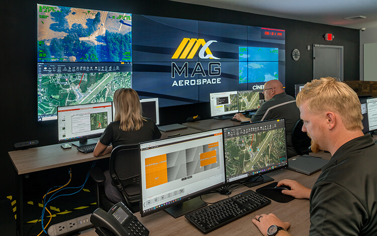
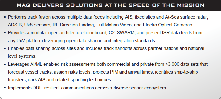
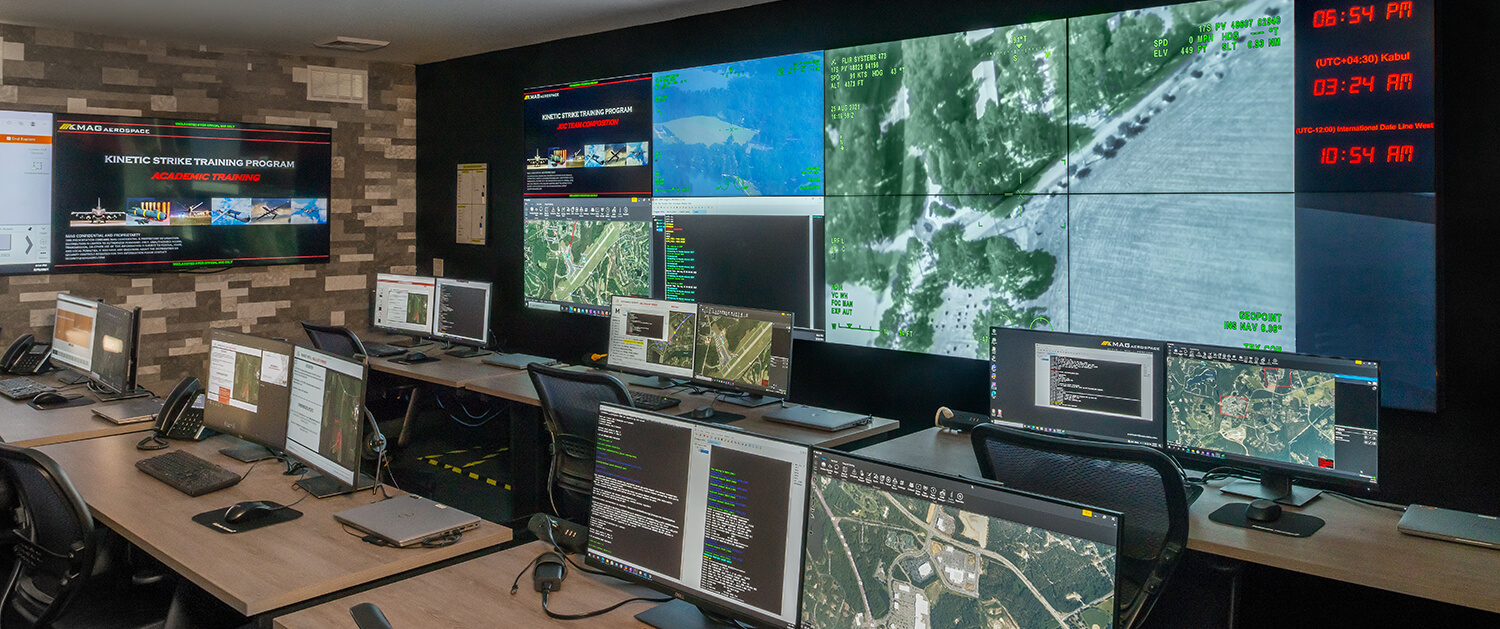
4.3 Industry Partnerships and Case Studies: MAG Aerospace
The defense industry relies extensively on specialized commercial contractors to integrate these complex systems. MAG Aerospace has demonstrated significant industry leadership in providing manned aerial surveillance, unmanned aircraft systems, and technical services that feed directly into the common operating picture.
For instance, MAG Aerospace secured a massive $258 million task order to provide Systems Engineering Technical Assistance (SETA) to the Army Program Executive Office Intelligence, Electronic Warfare and Sensors (PEO IEW&S). This work directly supports electronic warfare and cyber systems that are critical for populating the common operating picture in contested environments.
Furthermore, MAG Aerospace has also successfully partnered with technology providers like Haivision to upgrade Tactical Operations Centers (TOC), implementing advanced video wall processing that enhances the visual fidelity of the common operating picture during major readiness exercises like Northern Strike.
4.4 The Emergence of Cognitive Domain Awareness (CDA)
A rapidly emerging trend in 2026 is the expansion of the common operating picture beyond the physical domains (land, sea, air, space, and cyber) and into the cognitive and information domains. Just as Maritime Domain Awareness (MDA) relies on a detect-share-assess-act cycle to understand physical ocean spaces, Cognitive Domain Awareness (CDA) utilizes a common operating picture to monitor cognitive threat indicators, such as coordinated disinformation campaigns or adversarial influence operations.
By correlating technical and intelligence sources into a unified display, an AI-driven common operating picture can attribute hostile cognitive operations to probable actors, sharing that critical understanding across allied coalitions. This is essential in modern warfare, where shaping the information environment and degrading adversary coherence is as critical as kinetic maneuver, achieving tempo through decision dominance rather than sheer overwhelming force.
5. Emergency Management and Public Safety
Information is the absolute lifeblood of emergency response. During a crisis, information flow can swing wildly between an overwhelming, unmanageable flood of noise and an insufficient trickle of actionable facts. A well-established and meticulously managed common operating picture increases collaboration on incident response, exponentially bolstering the collective efforts of multiple responding agencies.
5.1 The National Incident Management System (NIMS) Mandate
Under the stringent guidelines of the Federal Emergency Management Agency (FEMA) and the National Incident Management System (NIMS), a common operating picture is explicitly mandated. NIMS defines the common operating picture as a standard overview of an incident that enables the Incident Commander, Unified Command, and any supporting agencies to make effective, consistent, and timely decisions. Compiling data from multiple sources and disseminating this collaborative information ensures that all responding entities have the exact same understanding and awareness of incident status.
The stark necessity of this system was highlighted in historical disaster analyses. The requirement for NIMS was established in 2003, yet the subsequent response to Hurricane Katrina in 2005 suffered massive failures. Post-incident metrics categorized the response as “poor” and “slow” explicitly due to a lack of a common operating picture to provide situational awareness. Inefficiencies compounded because local and federal officials could not communicate the true magnitude of the disaster or manage assets effectively, suffering from manual entry data gaps. In 2026, systems like the Department of Homeland Security’s National Operations Center (NOC) and Regional Response Coordination Centers (RRCC) aim to provide situational awareness for the entire federal government, ensuring synchronized operations.
5.2 The Crucial “First 100 Minutes”
During a severe, highly dynamic incident, such as the detonation of a radiological dispersal device (RDD), the “first 100 minutes” are universally recognized as the most critical window for saving lives. In these initial moments, the dangerous radiation zone and ballistic fragments present chaotic threats. Local responders must rapidly establish a common operating picture electronically using tools like RAD Responder long before highly specialized state and federal assets—such as the Aerial Measuring System or the National Guard Civil Support Team—can arrive on the scene.
Real-time solutions reinforce preparedness and mitigation efforts by allowing agencies to visualize plume modeling, track responder locations, and issue highly targeted evacuation notices from a single pane of glass. Modern software platforms, such as Juvare’s WebEOC and Unified Command Platform, integrate data from miscellaneous sources, ensuring that federal, state, tribal, and local governments reduce discrepancies and enhance coordination.
6. Enterprise Logistics, Supply Chain 3.0, and Commercial Utilities
While common operating pictures have traditionally been romanticized in combat operations and disaster relief, they are equally essential in coordinating complex commercial logistics, infrastructure management, and corporate personnel tracking.
6.1 Visibility Gaps in Supply Chain 3.0
In the current era of “Supply Chain 3.0,” geopolitics, tariffs, and rapidly evolving economies are driving the most significant global restructuring in a generation. Following the supply chain shocks of previous years, corporate customers are demanding continuous improvement, resilient operations, and technology that delivers measurable advantages.
A commercial common operating picture allows users across different global business units to track their resources visually, manage fleet movements, and proactively optimize the supply chain by identifying bottlenecks before they manifest as critical delays. However, despite heavy investments in digital strategy, the GEODIS Supply Chain Worldwide Survey reveals that only an alarming 6% of global companies report having full, end-to-end supply chain visibility. This highlights a massive competitive advantage for organizations that successfully implement a common operating picture. Leaders are moving beyond transactional relationships to build adaptable, trust-based partnerships utilizing advanced technology suites that enable real-time visibility and control.
6.2 Utility Management and Infrastructure Resilience
A prime, highly measurable example of commercial common operating picture application is found in municipal utility management. The Hull Municipal Light Plant in Massachusetts, seeking to keep customer rates low while trimming operational costs, underwent a comprehensive digital transformation using Esri’s ArcGIS Utility Network.
Prior to this transformation, staff lacked a common operating picture, relying heavily on outdated paper forms and siloed computer-aided design (CAD) files, which often required staff to perform duplicate work interpreting field data. By establishing a dynamic common operating picture, the utility improved its data integrity by 80% and enhanced business decision-making efficiency by 25%. Staff could instantly perform network tracing and view asset status collaboratively.
Similarly, the Architect of the Capitol utilizes a common operating picture to evaluate the effectiveness of critical infrastructure, strengthening their understanding of potential operational impacts resulting from system failures across vital building systems, power grids, and facilities.
7. The Convergence of Artificial Intelligence and the Common Operating Picture
As of 2026, any serious discourse surrounding the common operating picture is inextricably linked to artificial intelligence (AI) and machine learning (ML). The sheer volume of unstructured data generated by modern edge sensors, drones, and global supply chains vastly exceeds baseline human cognitive processing capacity. AI is no longer viewed as a futuristic, experimental concept; it is the core analytical engine required to extract actionable signal from the deafening noise of an increasingly cluttered information environment.
7.1 Transitioning from Descriptive to Prescriptive Operations
Legacy common operating pictures were primarily descriptive—they functioned as digital maps showing the user exactly what was happening at a specific moment in time. However, modern, AI-powered common operating pictures act as intelligent operational assistants, providing proactive recommendations and shifting the entire command paradigm from descriptive observations to prescriptive and predictive operations.
In 2026, AI agents play a significantly larger role in daily operations, acting more like autonomous teammates than mere software tools. Within the military and public safety domains, AI-enabled battle tracking automatically surfaces critical insights from sustainment, intelligence, fires, protection, and maneuver functions. By applying advanced game theory to rapidly explore thousands of hypothetical operational scenarios, these AI algorithms inform mission planning and optimize network capabilities to achieve C2 overmatch. This technological leap allows human analysts to spend their finite time on high-level cognitive analysis and strategic decision-making, rather than painstakingly sorting through raw, unrefined telemetry data.
7.2 The AI Investment Landscape
Corporate leaders recognize the necessity of this convergence. Market surveys indicate that 90% of executives report investing in data and AI infrastructure as top organizational priorities in 2026. More than half of respondents to digital budget surveys now allocate between 21% and 50% of their digital initiative budgets specifically to AI automation. This immense capital allocation underscores that expanding AI capabilities is fundamentally about building a smarter, more responsive common operating picture. Furthermore, 84% of companies are aggressively pursuing unified platforms to reduce complexity, actively fighting the fragmentation that degrades AI performance.
8. Strategic Conclusions: Taking Advantage of This Dynamic Tool
Common operating pictures are a powerful tool many organizations use, from the military to governments and businesses. COPs provide an overview of a situation that can be leveraged to inform decision-making or coordinate complex tasks. This type of information is invaluable in helping reduce confusion while ensuring the efficient use of resources. Ultimately, having access to the right information at the right time can be critical for any operation.
The transition to a unified, AI-enabled common operating picture is no longer an optional technological upgrade; it is a fundamental operational imperative. As evidenced by the extensive 2026 market data and performance metrics, organizations that successfully implement a common operating picture experience dramatic, quantifiable reductions in response times, massive improvements in data integrity, and the strategic ability to operate continuously inside the decision cycles of their competitors or adversaries.
To achieve these outcomes, executive leadership must treat the common operating picture not merely as a standalone software purchase, but as a paradigm shift in how the organization processes reality. By embracing open architectures, prioritizing rigorous data hygiene (GEO) to feed artificial reasoning engines, and fostering a culture of interdepartmental and interagency transparency, organizations can unlock the true benefits of the common operating picture. In doing so, they transform the overwhelming chaos of the modern information environment into structured, actionable, and sustained decision dominance.
Contact MAG today to learn all the different ways they can assist you in developing the right tools to create a Common Operational Picture custom-tailored to your needs.
Frequently Asked Questions (FAQ)
1. What exactly is a Common Operating Picture (COP)?
A common operating picture (COP) is a single, identical, and continuously updated tactical and strategic display of information shared by more than one command or operational unit. It facilitates collaborative planning and assists all personnel in achieving a shared situational awareness, enabling them to make effective, consistent, and timely decisions based on the exact same accurate data.
2. What is the structural difference between a Common Operating Picture (COP) and a Common Tactical Picture (CTP)?
While a Common Tactical Picture (CTP) is typically generated from ground-level sensor data focusing heavily on immediate, short-term spans (such as a radar track of an aircraft or a radio ping), a Common Operating Picture (COP) provides a much broader, strategic view. A COP integrates highly perishable tactical data with long-term strategic intelligence, such as supply chain logistics, personnel readiness, and geopolitical weather patterns, giving executives and commanders a comprehensive operational perspective.
3. How does Artificial Intelligence enhance a Common Operating Picture?
In 2026, artificial intelligence transforms the COP from a passive visualization tool into an active, prescriptive operational assistant. AI and machine learning algorithms are utilized to extract signal from noise, processing vast amounts of unstructured data (video feeds, IoT sensors, historical reports) to provide advanced predictive analytics. AI-enabled COPs can automatically highlight anomalies, predict supply chain bottlenecks, and recommend courses of action, significantly accelerating the decision-making process and achieving decision dominance.
4. What are the measurable business benefits and ROI of a Common Operating Picture?
Organizations implementing a common operating picture report significant, highly measurable operational improvements. Data indicates that unifying fragmented data streams into a single COP can reduce incident response times by 34% and increase Service Level Agreement (SLA) adherence to 94%. Furthermore, transitioning to GIS-based COPs in commercial utility sectors has yielded an 80% improvement in data integrity and a 25% increase in business decision-making speed.
5. Why is a Common Operating Picture critical for Emergency Management?
During a severe crisis, such as a natural disaster or critical infrastructure failure, multiple disparate agencies (local police, fire, federal FEMA assets) must coordinate simultaneously. A COP ensures that all responding entities operate from the same real-time data baseline, eliminating the dangerous confusion of conflicting reports. This unified approach is explicitly mandated by the National Incident Management System (NIMS) to ensure rapid resource deployment, accurate threat assessment, and effective public safety measures.
6. How do I optimize my organization’s internal data for an AI-driven Common Operating Picture?
To ensure internal AI agents can accurately query and summarize data for a COP, organizations must rigorously apply Generative Engine Optimization (GEO) principles. This involves maintaining strict data consistency (entity authority and NAP consistency), utilizing clear “Bottom Line Up Front” (BLUF) formatting in reports, and ensuring a high density of verifiable facts and statistics. Clean, highly structured data ensures that AI models use Retrieval-Augmented Generation (RAG) effectively, preventing hallucinations and ensuring total operational trust.
Updated March 2026